Up next in 10


The US-Canada border is one of the most well known, most crossed borders in the entire world. And because both countries have been friendly for so long, you might think that this means the border is pretty simple, right? The reality is anything but. The US-Canada border is filled with small little oddities that make you question whether this is really a border at all!
Show More Show Less View Video Transcript
0:00
At 5,525 miles, the US-Canada border is super long, but given how friendly these countries are
0:07
you would think that the border would be pretty simple, but that's not actually the case
0:12
In fact, this is one of the weirdest borders in the world
0:16
There's a lot to cover here, so let's dive in. The United States-Canada border spans the entire North American continent
0:27
And because of this, it crosses a wide range of geography. So before we do anything else, let's take a look at where the border goes
0:35
So, starting on the Atlantic coast between Maine and New Brunswick, the border first wanders north through thick forests and rugged highlands
0:43
before circling back around to the south, where it follows the 45th parallel to the Great Lakes
0:48
Here, it follows the water systems of Lakes Ontario, Erie, Huron, and Superior
0:54
with the iconic Niagara River and the Thousand Islands region acting as natural boundaries
1:00
After the Great Lakes, the border follows the Pigeon River separating Minnesota from Ontario
1:05
before straddling about a hundred different lakes, including the infamous Lake of the Woods
1:11
where the border juts north and then makes an abrupt U-turn back towards the 49th parallel
1:17
And don't worry, we're going to cover this in a minute. The 49th parallel section of the border is largely defined by flat, expansive farmland
1:24
with subtle changes in elevation and the occasional interruption of rivers like the Red River of the North
1:30
Of course, though, as the border approaches the Rocky Mountains, the terrain becomes more dramatic
1:36
cutting through alpine forests and rugged peaks. Glacier National Park in Montana and Waterton Lakes National Park in Alberta
1:42
straddle the border, creating one of the most beautiful areas along the entire border
1:48
Further west, the boundary winds through British Columbia and Washington State, traversing temperate rainforests, coastal mountain ranges, and the Columbia River Basin
1:57
It eventually reaches the Pacific Ocean near the Strait of Juan de Fuca
2:01
where the maritime border delineates territorial waters. But that's just the southern part of the border
2:07
To the north, Alaska's boundary with Canada arcs dramatically northward. This segment follows natural features such as mountain ranges, rivers, and valleys
2:16
including the Yukon River and the towering St. Elias Mountains, home to some of the continent's highest peaks
2:23
Now that you know the border's path, let's dive into all of the weird bits and pieces of it
2:32
As already mentioned, the U border is 5 miles which already makes it the longest international border in the world To put that in perspective the second longest border the one between Russia and Kazakhstan is significantly shorter at 4 miles
2:51
That's an incredible length for a border considering that any place where you can cross over
2:56
has to be staffed by border agents from both countries. That said though, and thankfully for both countries
3:02
the border remains undefended from a military standpoint, a testament to the peaceful existence between the two countries
3:09
Though there are quirks. The first really weird part of this border is between Vermont and Quebec
3:15
Derby Line, Vermont is in a unique situation where the international border cuts through the town
3:20
and even through buildings. The most famous example of this is the Haskell Free Library and Opera House
3:26
which was deliberately constructed astride the border in the early 1900s as a symbol of international friendship
3:33
Today, the library's front door is in the United States, while its bookshelves and reading room are in Canada
3:40
Visitors can cross the border simply by stepping from one room to another
3:44
although stricter post-9-11 border security has complicated this otherwise charming arrangement. The border also slices through private homes
3:52
meaning residents might eat breakfast in the U.S. and sleep in Canada. You should note, though, that if you want to fully enter Canada proper
3:59
you'll still need to go through customs via the road down the street. Speaking of roads crossing borders though, there's one road, also located in Vermont
4:08
that does cross the border into Canada for about 550 feet before dipping back into the United States
4:14
Just outside the town of Richford is East Richford Road, which crosses into Canada by about 100 feet
4:20
And unlike basically every other road that goes into Canada, you don't need to go through customs for this one
4:26
though you certainly won't be driving much farther into Canada either. But those are just the small oddities
4:31
So let's get to the bigger stuff. A large portion of the U.S.-Canada border famously follows the 49th parallel
4:39
stretching about 1,260 miles from Minnesota's Lake of the Woods to the Strait of Georgia in the Pacific Northwest
4:46
Often cited as one of the world's longest straight borders, it showcases the 19th century trend of using latitude lines as political boundaries
4:55
This boundary is so sharply defined that it literally slices through forests
5:00
creating a visible divide. But the story gets even more intriguing. The 49th parallel doesn't continue straight to Lake Superior
5:07
as one might expect. Instead, the border dips south along the Pigeon River
5:13
a quirk rooted in the 1783 Treaty of Paris, which ended the American Revolutionary War
5:19
The treaty relied on outdated maps and vague descriptions leading to later corrections when surveys revealed the actual geography of the region Similarly the 49th parallel bypasses Vancouver Island entirely
5:32
leaving the island entirely within Canadian territory. This arrangement was the result of
5:36
the Oregon Treaty of 1846, which resolved a boundary dispute between British and American
5:42
settlers in the Northwest. While the US secured rights to land south of the 49th parallel
5:47
the British insisted on retaining Vancouver Island, a strategic and economically valuable
5:53
region at the time. The treaty's language was ambiguous enough to lead to further disputes
5:58
however, including the infamous Pig War of 1859 that would ultimately lead to the San Juan Islands
6:04
becoming part of the United States. Moving back east, the border through Maine is another oddity
6:11
Unlike the straight-line simplicity of the 49th and 45th parallels that define much of the border
6:15
Maine's boundary with Canada is a twisting, jagged line that owes its shape to the Aroostook War
6:22
a boundary dispute between the U.S. and Britain in the 1830s and 1840s. Once again, the Treaty of
6:28
Paris had vaguely defined the border between Maine and New Brunswick, leading to conflicting
6:33
claims over the area. The Webster-Ashburton Treaty of 1842 eventually settled the issue
6:38
but only after protracted negotiations and near-armed conflict. The resulting border follows
6:44
rivers and mountain ridges, which explains its irregular shape. But the question remains
6:50
why didn't they simply extend the 45th parallel, which forms much of the border between Vermont
6:54
and Quebec, eastward to the Bay of Fundy? Who can say? Beyond these larger quirks
6:59
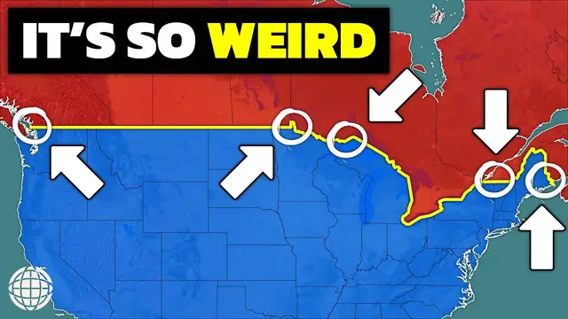
the border's micro-anomalies are even more intriguing. Let's first head to the northwest
7:04
angle of Minnesota, a small piece of land north of the 49th parallel that is cut off from the rest
7:10
of the United States. This border oddity is the result of yet another treaty mishap. The Treaty
7:16
of Paris that defined the northwest boundary of the U.S. as running through the northwest angle
7:20
of the Lake of the Woods was based on faulty maps of the region at the time. When the true geography
7:25
of the lake was uncovered, it left this isolated pocket of U.S. territory accessible only by boat
7:31
or by crossing through Canada. Today, about 100 people live in the area. Further west lies Point
7:38
Roberts, Washington, a tiny U.S. exclave south of Vancouver. This community exists because the
7:44
49th parallel slices through the southern tip of the Sawasin Peninsula. As a result
7:49
Point Roberts is cut off from the rest of the United States and is accessible by land only
7:54
through Canada. Residents must cross the border multiple times a day for work, school, and other
7:59
necessities The closeness of Point Roberts to the major city of Vancouver British Columbia has led to some odd demographic traits such as people living in the U Point Roberts and working in Vancouver in order to satisfy specific visa
8:13
requirements. Similar to Point Roberts, in Quebec, the Akwesasne Mohawk Territory straddles the U.S.-Canada
8:20
border, extending into both Quebec and New York. The Akwesasne people have lived in this region for
8:26
centuries, long before international borders were drawn. But today, the community has to navigate a
8:32
patchwork of jurisdictions across both countries, with residents regularly crossing international boundaries to access schools, healthcare, and other services. This has led to there being two
8:43
Akwesasne towns, one on the small peninsula jutting into Quebec, and the other firmly rooted in New
8:49
York State. Despite this international boundary separation, the Akwesasne people consider themselves a single community. Then there's Hyder, Alaska, a remote town that can only be accessed by
9:01
land from Canada. Surrounded by mountains and forests, Haider is geographically isolated from
9:07
the rest of Alaska, and its residents rely heavily on the nearby Canadian town of Stewart
9:12
British Columbia for services. In fact, Haider is so dependent on their Canadian neighbors that the
9:18
town primarily pays for things using Canadian currency. Residents also use the British Columbia
9:24
250 area code rather than Alaska's 907. They manually change their clocks to British Columbia's
9:30
Pacific time zone rather than the Alaska time zone, and they even celebrate Canada Day. The
9:37
border here is mostly a technicality, with a level of integration that blurs the line between the two
9:43
countries. Back east, a similar but opposite situation exists on the island of Campobello
9:48
in New Brunswick. Although the island is part of Canada, its only road connection is to the U.S
9:53
state of Maine via the Franklin Delano Roosevelt Bridge. As such, Campobello residents must cross
9:59
the border for most of their shopping, healthcare, and other needs despite living in Canada. This
10:04
reliance on the U.S. has created consistent requests from the island's residents for a bridge
10:09
that directly connects to Canada as ferry service is inconsistent through the spring, summer, and
10:14
fall, and far too dangerous during winter. There's so many more little weird spots on the U.S.-Canada
10:21
border, but I had to draw the line at my very favorite oddities. If this video got you super
10:26
stoked on either the U.S. or Canadian geography, well, be sure to check out my map store and buy a
10:32
map for your walls. Every map you buy helps support this channel. I hope you enjoyed watching and
10:37
learning all about the U.S.-Canada border. If you did enjoy it, please like the video and subscribe
10:41
to the channel. And check out this video on 15 incredible geography facts of the United States
10:47
Thanks for watching. See you next time
#education