Up next in 10


The United States has an interesting population distribution. You can find any number of videos talking about why so many more people live on the eastern half of the country. But what's rarely talked about is this large empty belt in the middle of the country that has less than 1% of the total U.S. population. In this video, we go over some of the reasons why this area, from Canada to Mexico, is so relatively underpopulated.
Show More Show Less View Video Transcript
0:00
The United States is one of the largest countries in the world in terms of both size and population
0:06
But the United States population is not evenly distributed across the country
0:10
And while most people live on either the eastern half of the country or the west coast, there's a really large belt of land in the middle of the country that is almost entirely empty
0:19
Here's why. Hello and welcome to Geography by Jeff. Now, if you've ever seen this photo
0:29
you'll no doubt know that most of the population and infrastructure is concentrated
0:32
in the eastern half of the United States. But while that's an interesting story unto itself
0:37
what we're gonna talk about today is a really large swath of land that runs from the northern border of Canada
0:42
down to the southern border with Mexico that relatively few people live in
0:47
But before that, if you want even more geography from me, check out the What If Geography podcast
0:52
where myself and Professor Hunter Shobi we tackle the great big what-if questions of the world
0:57
New episodes premiere every Wednesday, and you can catch the podcast right here on YouTube
1:01
or whatever podcast app you use. Before we can talk about the United States empty belt
1:10
we have to first talk a little bit about the country's population distribution at large
1:14
The United States as a whole is very concentrated on the eastern half of the country
1:18
In fact, there's basically a line you can draw across the country that splits the contiguous United States in half
1:23
On the eastern side of this line, roughly 80% of the country's population lives, and on the other, roughly 20%
1:30
And the reason for this is largely due to a confluence of factors that includes the natural geography and where the United States began its existence
1:39
In both of these cases, the eastern half of the country is geographically less challenging
1:43
but at the same time, it's also where the United States was first settled when it began as a series of colonies derived from the British Empire
1:50
This led towards an earlier and easier development of the land, beginning on the east coast
1:56
From there, the United States gradually expanded west. Beginning in 1803 the United States acquired a huge area of land from France that included much of the modern Midwestern region of the country This purchase also aligned nicely with the Mississippi River watershed a region so vast in its quantity of fresh water that it not only allowed for relatively easy
2:15
irrigation of agricultural land, but it also allowed for trade and travel by ship. The combination of
2:21
easy agriculture and easy transportation was a recipe for rapid development. At around the same
2:26
time, development began to spur along the West Coast as well. San Francisco, for example, was
2:31
officially incorporated in 1850, just 13 years after the city of Chicago. Los Angeles was
2:37
incorporated in 1850 as well, and Portland, Oregon in 1851. The point being that development on the
2:42
west coast was not all that far behind the Midwest region, but it was stymied by the lack of quick
2:47
and reliable transportation. Basically, these cities were left to fend for themselves for much
2:51
of their early existence and relied primarily on natural resource boom and bust cycles to drive
2:56
early populations of people. This would include the 1849 gold rush to Northern California
3:01
As the decades wore on and transportation and livability technologies improved, other major cities have been developed and established as major population centers
3:09
throughout the middle of the country. Boise, Phoenix, Salt Lake City, and Denver all incorporated
3:14
between 1860 and 1900. From there, the western half of the country began to develop and population
3:20
grew steadily. But while that's all well and good, there's been one area of the United States that
3:25
hasn't grown all that much. This large belt that cuts the contiguous United States in half
3:30
The population distribution of a country is always an interesting story. If one specific region is growing faster than others, there's a story behind that. Likewise
3:39
if a region is relatively underpopulated, there's also a story behind that
3:43
But before we dive into why the United States has such a large underpopulated belt
3:48
if you're enjoying this video, now would be a great time to subscribe
3:51
More fun what if geography videos are just a single click away
4:00
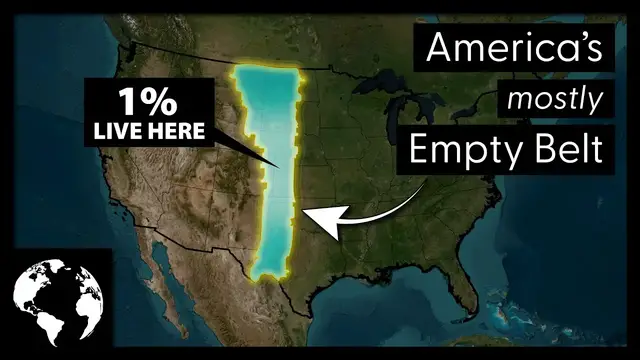
Nowhere else in the rest of the contiguous United States is there such a large connected
4:04
piece of land that is so relatively empty. The entire area stretching from the Canadian border to the Mexican border is just about 350 square miles To put this number in perspective if this area was its own state it would be larger than any current existing state aside from Alaska
4:21
which is about 570,000 square miles. All told, it makes up approximately 12
4:26
of the contiguous United States. But while its size is vast, that's only half the picture
4:32
The total population of this belt is just 3.1 million people, or less than 1% of the United States total population
4:39
That's almost equal to the same size as the metropolitan area of Denver, Colorado
4:43
which we'll get to in a little bit. In every other region of the contiguous United States
4:48
multiple major population centers will break up the otherwise expanse of rural farms
4:52
mountains, or forests. And that's not to say there aren't any population centers, but they're still fairly small
4:58
The largest population centers within the belt are Lubbock, Texas, Amarillo, Texas, Midland, Texas
5:05
Abilene, Texas, Rapid City, South Dakota, Bismarck, North Dakota, San Angelo, Texas
5:11
and Odessa, Texas. From there, population within cities and towns starts to drop quickly
5:17
And if you're noticing a trend here, you're right. Texas has the vast majority of the Belt's population
5:22
and there's a few reasons for that. So we've established that for its size
5:30
and geographic position within the United States, the Belt is definitely underpopulated
5:34
The only question now is, why? As with most things, there's never really a single answer
5:40
Instead, it's a confluence of things that form to create the present day scenario
5:44
In this case, we have roughly three reasons why this belt has been left so underpopulated
5:48
stretching even into 2022. The first and most prominent reason likely lies within a few Native American tribes
5:54
that put up some of the fiercest resistance to the US military at the time
5:59
Within this belt of land lies five historic tribes. The Sioux Tribe, Cheyenne Tribe, Kiowa Tribe, Comanche Tribe, and the Apache Tribe
6:08
These tribes all tirelessly and with great effort attempted to stop the US military and
6:13
US settlers from encroaching on their lands. By the late 1800s the tribes were unfortunately decimated and forced to relocate to reservations But by that time development within much of the western half of the country had already outpaced this region in particular
6:28
leading to it already being well underdeveloped. While indigenous tribes putting up resistance was
6:32
certainly a contributing factor during their early years of settlement, it doesn't account for why
6:36
the land wasn't heavily developed afterwards. And much of this is due to the effect the Rocky
6:41
Mountain Range has on the area immediately to the east of it. You see, the Rocky Mountains create
6:46
what is called a rain shadow effect wherein moisture is built up on the western side
6:50
precipitation is dropped throughout the range, and then nothing is left for the eastern side
6:55
This creates an area that is mostly either arid or otherwise downright cold. According to the
7:00
Coppin Climate Method of Determining Climate Across Geographies, this particular belt is 64
7:06
arid steppe or arid deserts, 28% cold and dry climate, and only 8% temperate. This means that
7:13
any sort of real agriculture, a primary motivator for settling in the 1800s and early 1900s
7:19
was very limited. But there's one more thing that still stymies population moving to this region
7:24
wild temperature fluctuations. If you've ever heard about an area going from about 70 degrees
7:29
Fahrenheit to 30 degrees Fahrenheit in the course of a single day, it's probably from this particular
7:34
region or close to it. And this largely has to do with the continentality of this area in particular
7:40
which allows for polar wind to drop into the region fairly quickly
7:44
similar to what we saw happen very recently. All that's to say, weather is a huge reason people do or do not move to someplace
7:52
and this region does not have mild weather. No country in the world is equally distributed, and most people move for economic reasons
7:59
If a city or region is growing or shrinking, it's likely due to the economy
8:03
For the belt, there's just not a whole lot of reasons for people to move there
8:07
and there are active aspects such as the weather and climate that actively prevent people from moving there
8:13
For those reasons, the area will likely remain underpopulated well into the future
8:17
I hope you enjoyed learning a bit about the United States underpopulated belt
8:21
If you did, please subscribe to my channel. And if you wanna watch more of my videos
8:26
you can do so here. Thanks for watching, see you next time
#education