Up next in 10


Listen to the companion podcast episode here: https://linktr.ee/geographyiseverything
Instagram: https://www.instagram.com/geographybygeoff/
Threads: https://www.threads.net/@geographybygeoff
Podcast: https://www.spreaker.com/show/geography-is-everything
Linktree for everything: https://linktr.ee/geographybygeoff
The Mighty Mississippi is truly one of the mighty rivers of the world. And like other mighty rivers, it has become an integral part of the land, people, and country it exists within. However, unlike other major rivers in the world such as the Nile, Congo, or Ganges rivers, the Mississippi River has never amassed a large single population center, particularly along its southern half. So why don't more Americans live along the Mississippi River?
Stock footage is acquired from www.storyblocks.com.
Animation support provided by DH Designs (needahittman.com)
Show More Show Less View Video Transcript
0:00
The Mississippi River is the most important river in the United States
0:04
stretching from almost the very north at the border with Canada to the Gulf of Mexico in the
0:08
south. But despite its importance, the southern half of the Mississippi River does not have any
0:14
major U.S. cities and a shockingly low population overall. So why don't more people live along what
0:20
is otherwise an incredibly important trade and transportation river of the United States
0:25
Welcome to Geography by Jeff. Today we're off to explore the mighty Mississippi River
0:33
But despite being so mighty itself, its overall population distribution pales in comparison to that of other major rivers in the world
0:40
particularly along the river's southern half. And as usual, there's a geographic reason for this
0:46
But first, be sure to check out this week's podcast episode all about solar energy
0:50
Building off our episodes on nuclear energy, wind energy, and hydroelectric dams
0:55
you can now follow along with us as we explore the geography of, well, kind of the sun
1:00
You can listen to the episode right after this video by clicking this link, or by checking out the description below
1:08
The Mississippi River, a geographic marvel of North America, stretches approximately 2,320 miles from its source at Lake Itasca in Minnesota
1:17
to its mouth in the Gulf of Mexico. This vast valley encompasses a diverse range of landscapes, including woodlands, bluffs, marshlands, and numerous tributaries, making it one of the world's largest drainage systems
1:30
In fact, the Mississippi River Valley is so large that, when laid over the contiguous United States, it takes up about 40% of all land
1:37
And of course, the Mississippi River itself meanders through or borders 10 US states
1:43
Minnesota, Wisconsin, Iowa, Illinois, Missouri, Kentucky, Tennessee, Arkansas, Mississippi, and Louisiana. While it doesn't directly traverse any Canadian provinces, its watershed reaches into Canada
1:57
by way of Alberta and Saskatchewan. Given all this, of course, one of the defining features of the Mississippi River Valley is
2:04
the immense volume of water it carries. On average, about 600,000 cubic feet per second flow through the lower Mississippi near New Orleans
2:12
though this can vary greatly due to seasonal changes and upstream rainfall
2:16
Regardless, that's a huge amount of water. That said, it's maybe not as big as many might expect
2:22
All told, the Mississippi River is the 13th largest river in the world by average volume
2:27
well behind the likes of the Amazon River, Ganges, and Congo River
2:31
Several major rivers contribute to the Mississippi as tributaries, significantly expanding its reach and impact
2:37
The most notable of these include the Missouri River, the longest tributary merging with the Mississippi near St. Louis, Missouri
2:44
It extends the Mississippi's reach into the Great Plains, covering states like Montana, North Dakota, South Dakota, and Nebraska
2:50
The Ohio River, another significant tributary, joining the Mississippi at Cairo, Illinois
2:56
It serves as a natural boundary for several states, including Pennsylvania, Ohio, West Virginia, Kentucky, Indiana, and Illinois
3:04
The Arkansas River flowing from the Rocky Mountains in Colorado it meets the Mississippi and Arkansas providing a vital link to the Southwest The Red River originating in the Texas Panhandle this river flows through Texas Oklahoma Arkansas
3:19
and Louisiana before joining the Mississippi. And the Illinois River, a key tributary that joins the Mississippi near Grafton
3:26
It is an important waterway for the state of Illinois. These tributaries, along with thousands of smaller ones, contribute to the Mississippi
3:33
River's vast watershed, which covers approximately 1.2 million square miles, including parts of 31
3:39
U.S. states and two Canadian provinces. This extensive network not only supports a diverse
3:45
range of ecosystems, but also plays a crucial role in agriculture, transportation, and industry
3:50
in the central part of the United States. The Mississippi River Valley's geography
3:55
with its fertile soils and strategic location, has been a vital artery for human settlement and
3:59
development from indigenous peoples through colonization. But before we get to the history
4:04
of the Mississippi River Valley, if you're enjoying this video, hit that subscribe button
4:09
More fun geography videos are just a single click away. It probably doesn't need to be said, but the Mississippi River is one of the most significant
4:20
waterways in North America and has been for thousands of years that long predate the current
4:25
United States. Before European colonization, the river was central to numerous indigenous cultures
4:31
including the Mississippian culture known for their large, complex societies and mound building
4:36
These mounds, some of which still stand today, were ceremonial and social centers. For them
4:41
the river was a crucial trade and transportation route, fostering extensive networks among tribes
4:47
such as the Ojibwe, Sioux, and Chickasaw. With the arrival of Europeans in the 1500s
4:52
the Mississippi River became a focal point for exploration and later colonial ambitions
4:58
Spanish and French explorers like Hernando de Soto and René Robert Covellier
5:02
navigated its waters, laying the groundwork for future claims and settlements. The French, in particular, recognized its strategic importance
5:11
establishing outposts and integrating into the existing trade networks with Native Americans
5:16
As the Mississippi River Valley was more fully explored during the following centuries
5:19
the river became consistently disputed between Spain and France and was highly coveted by the
5:25
British. After various colonial conflicts and treaties, it became a border between French
5:30
Spanish, and British territories, and later a vital artery in the young United States
5:36
Cities like New Orleans, founded in 1718, grew into major ports due to their location along the
5:41
river. But despite its growing importance, the river was still fairly challenging to navigate
5:46
with pre-industrial technology. The 1800s brought dramatic changes with the invention of the steamboat
5:52
revolutionizing trade and travel along the Mississippi. This era also saw the river as a
5:56
contentious boundary in the expanding United States, particularly regarding the issue of slavery
6:02
During the Civil War, control of the river was a significant strategic goal, famously culminating
6:07
in the Siege of Vicksburg in 1863. In the modern era, the Mississippi River continues to play a
6:13
vital role in the United States economy and ecology It is a major conduit for agricultural and industrial transportation with an extensive network of locks dams and levees to manage its flow However this management has not been without challenges
6:27
Issues like pollution, habitat destruction, and the impacts of climate change on river patterns and floods are ongoing concerns
6:34
And it's these challenges that lay the foundation for why, despite its importance
6:38
there's actually not that many people who live along the Mississippi River, particularly the southern portion
6:47
Mighty rivers of the world are often found to have major population centers that dot their shores
6:53
Historically, this had to do with the availability of fresh water, fishing, and transportation access
6:58
Cities like Kinshasa along the Congo River, Cairo on the Nile, Montreal on the St. Lawrence
7:04
and Wuhan on the Yangtze are home to millions of people each
7:08
But the Mississippi River, despite being hugely important and very strategic, has far fewer and much smaller cities
7:15
And even more to that point, the difference between the northern half and the southern
7:19
half of the river is very stark. The Mississippi River, one of North America's most iconic waterways, presents a stark contrast
7:27
in population density along its length. While the northern half boasts major cities like St. Louis and Minneapolis, the southern
7:33
half, especially south of St. Louis, is notably less populated. This disparity is due to several geographic and environmental factors that have historically
7:42
influenced settlement patterns of the United States. At the confluence of the Ohio and Mississippi rivers, a location that might seem ideal for
7:49
a major city due to its strategic position for trade and transportation, the population
7:53
remains sparse with only the tiny town of Cairo, Illinois sitting at its confluence
7:58
This anomaly can be attributed primarily to the challenges posed by the river's natural
8:02
behavior and surrounding geography. One of the most significant factors is the prevalence of flooding
8:08
The region's topography and the river's dynamics contribute to frequent and sometimes
8:12
catastrophic floods, which has discouraged dense urban development. The Great Mississippi Flood of
8:18
1927, one of the most devastating floods in U.S. history, inundated over 27,000 square miles of
8:25
previously dry land in depths of up to 30 feet below water for several months. This example
8:30
exemplifies the risks associated with living in these flood-prone areas. The Yazoo Mississippi
8:36
Delta, a notable region along the southern stretch of the river, further illustrates these challenges
8:42
This area is an alluvial floodplain, meaning it is formed by sediment deposited by the river
8:47
While these sediments make the delta extremely fertile, they also contribute to its instability
8:51
and vulnerability to flooding. The delta soil composition and flat topography exacerbate flood risks
8:58
making it less suitable for large-scale urban development. Put plainly, establishing a large city in this region
9:04
is basically asking for it to be flooded in the future. Contrastingly, the northern half of the Mississippi
9:09
particularly around cities like St. Louis and Minneapolis, benefits from a different set of geographic conditions
9:15
These areas are less prone to severe flooding thanks to a combination of higher elevation
9:20
more stable soils, and a river that, in these regions, is easier to manage and control
9:25
This has allowed for more substantial urban development without the same level of risk in the southern half Furthermore historic development patterns have played a role The northern reaches of the Mississippi River were more accessible and appealing to European settlers in early American expansion
9:40
This led to earlier and more intensive development in the north, with cities like St. Louis and Minneapolis
9:45
becoming key economic and transportation hubs in the late 1800s and early 1900s
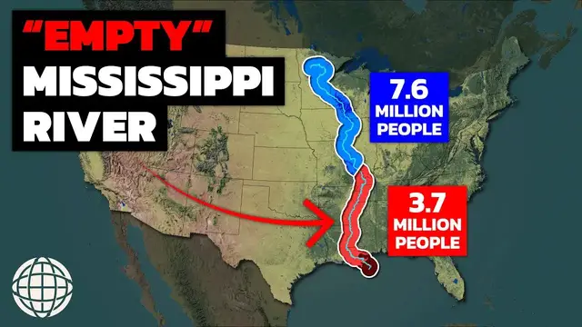
9:51
Today, the southern half of the Mississippi River is home to only about 3.7 million people
9:56
This would be led by Memphis, Tennessee with about 1.3 million people, New Orleans with about 1.2 million, and Baton Rouge with about 870,000 people
10:05
Aside from those three cities, there's not really another large urban area along this portion of the river
10:11
By contrast, the northern half of the Mississippi is home to about 7.6 million people
10:16
and is led by the major cities of Minneapolis, St. Paul, Minnesota with about 3.7 million people, and St. Louis, Missouri with 2.8 million people
10:24
These two cities have been able to grow so large in part because, well, the Mississippi
10:29
is far easier to control in the north. The unique and somewhat puzzling borders in the southern stretch of the Mississippi River
10:40
where states like Arkansas, Mississippi, and Louisiana have small exclaves on the opposite
10:44
banks, are a result of the river's dynamic nature and historic border agreements
10:49
This situation, primarily observed in the Mississippi Delta region, reflects the challenges
10:54
of defining political boundaries along a meandering river. The Mississippi River is known for its tendency to change course
11:01
often dramatically, due to natural processes like erosion, sediment deposition, and flooding
11:07
These changes can be gradual or sudden, the latter often resulting from avulsions during floods
11:12
where the river carves a new channel, abandoning its old course. When the Mississippi River changes its course
11:18
it can leave behind oxbow lakes and cut off sections of the river, leading to the creation of these exclaves
11:24
Historically, state borders in this region were defined based on the Mississippi River's course at the time the borders were established
11:30
These borders were intended to follow the river at the time, regardless of its future changes
11:35
However, when the river naturally altered its course, it didn't alter the pre-set political boundaries
11:41
leading to situations where a piece of land that was once on one side of the river finds itself on the other
11:46
Legally, these exclaves remained part of the state they were originally attached to
11:50
despite being geographically isolated by the river. This situation has led to unique administrative and jurisdictional challenges
11:57
including issues related to law enforcement, emergency services, and governance. But given that the original borders were set at the physical location of the Mississippi River at
12:05
the time, there's little recourse to change it in the future without congressional approval
12:09
by the United States federal government. The Mississippi River is truly one of the
12:13
United States' most important geographic features, but that doesn't mean it's made
12:17
establishing large urban centers easy. In fact, unlike other major rivers of the world
12:22
the Mississippi River is uniquely challenging. And because of that, the southern half of the Mississippi River
12:28
will likely remain underpopulated for a long time. I hope you enjoyed learning more about the Mississippi River
12:34
If you did, please subscribe to my channel. If you wanna listen to the podcast, you can do so here
12:39
If you wanna watch another video, click here. Thanks for watching. See you next time
#education