Up next in 10


International borders decide who gets to have control over what territory. And because of this, these are often hard lines drawn in the sand that determine who gets to cross. But that doesn't mean they all make sense! In fact, some international borders are incredibly bizarre!
Show More Show Less View Video Transcript
0:00
Every border that exists today is a made-up line that determines who controls whichever side
0:06
And because of this and human nature, we've ended up with a planet carved into somewhere around
0:11
200 separate sovereign countries. And these countries can sometimes have really weird borders
0:18
So here are the 10 most bizarre borders I could find and how they came to be
0:22
The villages of Barlhertog and Barl-Nassau create one of the world's most complex borders
0:32
with patches of Belgium and the Netherlands interwoven in a confusing mosaic of enclaves
0:37
and exclaves. This border situation is so intricate that some buildings and homes are
0:42
bisected by the international boundary, leading to peculiar situations where residents have
0:47
different nationalities depending on which room they're in. This convoluted arrangement dates back
0:52
to medieval land agreements between local dukes and noble families who owned interspersed plots
0:58
of land. Over time, shifting political landscapes solidified these boundaries resulting in today's
1:04
unique patchwork. Visitors to Barl are charmed by the unusual sight of dual flags and boundary
1:10
markers running through streets, homes, and businesses. It's a rare case where two countries
1:15
cooperate seamlessly to maintain public services and infrastructure across such a fragmented
1:21
landscape. The border between the Republic of Ireland and Northern Ireland has long been a
1:29
symbol of conflict. Separating the independent Republic of Ireland from Northern Ireland
1:34
a part of the United Kingdom, the border has a legacy rooted in the Irish War of Independence
1:39
and the division of Ireland in 1921. For most of the 20th century
1:44
this line was a heavily militarized border due to the Troubles, a violent conflict over Northern Ireland's status
1:51
that persisted until the Good Friday Agreement in 1998. The agreement brought peace
1:57
and enabled free movement across the border, blending communities and creating economic ties
2:02
However, Brexit's introduction of a customs border with the EU has revived concerns
2:07
about potential disruptions. Instead of implementing a hard border on land, the UK and EU reached a compromise to maintain border-free trade between Ireland and Northern Ireland
2:17
effectively creating a customs border in the Irish Sea. This arrangement has caused political friction within the UK as Northern Ireland now operates under unique trade rules
2:27
But a hard border would be very complicated to implement, not only for geopolitical and trade reasons
2:33
but for the simple fact that Ireland and Northern Ireland are not all that separate anymore
2:37
The N-54 road, for example, will go from Ireland to Northern Ireland, then back to Ireland, back to Northern Ireland once again, before entering Ireland again over a 5 mile stretch
2:49
Can you imagine the border security that would be needed if this was a hard border once again
2:54
The Noim Corridor in Bosnia and Herzegovina slices through Croatia's coastline, interrupting its Adriatic coast and requiring travelers to cross a
3:07
foreign border to traverse the country by land. This unusual arrangement grants Bosnia and Herzegovina a small but significant access
3:15
point to the sea, though the coast remains largely undeveloped in this area
3:19
The corridor originated from the Treaty of Karlović in 1699, giving Bosnia and Herzegovina this strip of coastline as a buffer between the Venetian and Ottoman empires
3:31
When Yugoslavia dissolved in the 1990s the Neum Corridor remained Bosnia and Herzegovina only maritime outlet complicating Croatian transportation To ease travel Croatia recently completed the Pelyasac
3:43
Bridge, connecting its coastal regions without crossing through Bosnia and Herzegovina. The holidays are barreling towards us all like a freight train, and that means there's more to do
3:54
more to think about, and of course, more to buy. And that's stressful. That's why this holiday
4:00
season, I'm relying on HelloFresh more than ever. HelloFresh helps make mealtime manageable
4:06
saving you from needless grocery shopping. Just pick your meals and everything you need
4:11
is delivered right to your door. And of course, everything they send you is high quality
4:17
and sustainably sourced. My absolute favorite recipe this time of year has been the Thai
4:23
coconut curry tofu dish. It's both warm and savory. And during these colder months
4:28
It just hits the spot. So get 10 free meals at HelloFresh.com slash freegeography
4:36
Applied across seven boxes, new subscribers only, varies by plan. That's 10 free HelloFresh meals
4:43
Just go to HelloFresh.com slash freegeography. America's number one meal kit. Egypt and Sudan have a bit of a conundrum on their hands
4:57
At the same time, they're both claiming the same land and refusing to claim an area right next to it
5:03
The Halayb Triangle, a desolate area along the Red Sea, has been a point of contention between Egypt and Sudan for decades
5:11
Both countries claim this 20,000 square kilometer stretch of land, making it one of Africa's most enduring border disputes
5:19
The area is sparsely populated and of limited economic value, but both still want it
5:25
At the same time, and essentially right next to Halib, is Bir Tawil
5:29
a smaller, uninhabited area that has been left unclaimed by either Egypt or Sudan
5:35
This is largely due to the fact that if either country claimed Bir Tawil
5:40
it would then weaken its position to claim Halib, a much more attractive and lucrative plot of land
5:46
The conflict over the Halib triangle dates back to British colonial rule in the 19th century
5:51
While Egypt and Sudan were united as a British protectorate, discrepancies in boundary delineation left Halib's status ambiguous. Egypt and Sudan both claim it
6:02
based on differing interpretations of the 22nd parallel, the very same interpretations that have
6:07
left Bir Tawil as an unclaimed area. The Gambia, a narrow country that stretches along the Gambia
6:17
River, is almost entirely encircled by Senegal, save for a small Atlantic coastline. This creates
6:24
unusual dynamics for the Gambia with its surrounding neighbor. The border arrangement
6:28
can be cumbersome for trade and travel, with goods moving between different regulatory environments
6:33
despite the close proximity. The country is less than 50 kilometers wide at its widest point
6:39
Like with other African countries, this border owes its existence to European colonialism
6:45
When Britain and France divided the region, with Britain claiming Gambia and France taking control
6:49
of the surrounding area, today Senegal. This artificial division left Gambia as a long
6:55
thin territory, penetrating Senegal from the coast. Today, the two countries maintain generally
7:01
cooperative relations, but the border still presents economic and political challenges. Senegalese citizens often cross into the Gambia to travel across the region more efficiently and there have been discussions of a possible confederation However political and economic differences have prevented a full integration
7:20
Gambia's unique position inside Senegal remains an example of colonial borders' lingering effects on African countries
7:31
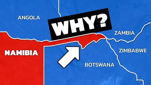
Namibia's Caprivi Strip, a narrow ribbon of land that extends nearly 450 kilometers eastward
7:37
creates one of Africa's oddest border configurations. This narrow strip is the result of European colonial ambitions
7:45
that have left lasting geographic oddities on the continent. Sandwiched among Angola, Zambia, Botswana, and Zimbabwe
7:53
the Caprivi Strip's geography resembles a handle protruding into central Africa, barely 32 kilometers wide at some points
8:01
The origin of this odd appendage dates to the 1890 Haligoland-Zanzibar Treaty
8:06
between Germany and the United Kingdom. Germany, then the colonial ruler of Namibia
8:11
negotiated for this land corridor. Germany's goal was to gain access to the Zambezi River
8:17
which was thought, at the time, to be a crucial link between its colonies in southwest Africa
8:22
today Namibia, and eastern Africa, today Tanzania. Unfortunately for the Germans, the Zambezi River was unnavigable due to Victoria Falls, one of the world's largest waterfalls
8:33
something the British already knew but intentionally hid from Germany as they wanted to sell the land
8:40
Today, the Caprivi Strip is a rich ecological zone home to diverse wildlife and communities that rely on the Zambezi River
8:47
which makes up its eastern border. But the strip also contributes to geopolitical tensions in the region
8:52
with its narrow border creating logistical and governance challenges for Namibia and its neighbors
8:58
Mata and Nawa are unique exclaves in the Middle East, where a piece of Oman, Mata
9:08
is surrounded by the United Arab Emirates, and within Mata lies Nawa, an exclave of the United
9:13
Arab Emirates. This creates a curious situation of an exclave within an exclave, a border oddity
9:20
that's both geographical and political. The origins of these exclaves trace back to local
9:25
tribal loyalties in the early 20th century. The tribes in Mata aligned with Oman, while Nawa
9:31
pledged loyalty to the United Arab Emirates. When the borders were drawn, these loyalties were
9:36
honored, leading to the establishment of the nested exclaves. Today, Mata and Nawa are peaceful
9:42
communities where residents navigate between Oman and the United Arab Emirates. This border
9:47
arrangement, while unusual, operates smoothly with road access and administrative arrangements provided by both countries. Mata and Nawa highlight the complexity of border arrangements
9:58
based on tribal affiliations, as well as the cooperation needed to maintain them
10:07
The Fergana Valley, nestled among Kyrgyzstan, Uzbekistan, and Tajikistan, is home to some of
10:13
the world's most complicated borders, with multiple exclaves that create a web of territorial
10:18
complexity. This configuration has contributed to ethnic tensions and border disputes, in an area rich with fertile soil that's perfect for agriculture. This is especially important
10:29
given the overall aridity of the region. Having a fertile piece of land is very valuable. The
10:35
valley's complicated borders originated from Soviet-era policies intended to create administrative divisions along ethnic lines. However, the resulting patchwork has led to isolated communities
10:46
with limited access to their parent countries occasionally sparking conflicts over resources and governance Today residents of the Fergana Valley frequently cross borders for daily activities
10:58
complicating relations between the three countries given that border controls are challenging to
11:03
enforce. The Guatemala-Belize border stands as one of the more bizarre borders in the world due
11:12
to its straight-line shape and ongoing dispute. In fact, the village of Arenal was bisected by the
11:18
border and maintains access to its Guatemalan side only by first going through Belize or by walking
11:24
across a single suspension bridge across the nearby Mopan River. To this day, residents of Arenal
11:30
still aren't quite sure where the border actually is. But what makes this border stand out is the
11:36
fact that the entirety of it is disputed. Guatemala specifically doesn't recognize the border
11:42
at all. This dispute has led to diplomatic strains and occasional tensions along the boundary
11:47
although the two countries remain in overall peace. The disagreement stems from conflicting
11:52
interpretations of an 1859 treaty between Britain, then Belize's colonial ruler, and Guatemala
11:59
When Belize gained independence in 1981, Guatemala did not initially recognize its sovereignty
12:05
arguing that the treaty was violated due to Britain's failure to build a road connecting
12:09
the two territories. Over time, international mediation helped de-escalate tensions, but Guatemala has continued to assert its claim, seeking a resolution at the International
12:20
Court of Justice. Belizeans strongly identify as an independent nation and have resisted
12:26
any encroachment on their territory. The Venezuela-Gayana border dispute centers on the Essequibo region, a vast, resource-rich area spanning approximately 160,000 square kilometers
12:43
This territory, covering over two-thirds of Guyana, is claimed by Venezuela, which contends that the
12:48
boundary was unfairly imposed by a colonial treaty. The region includes rich mineral deposits
12:55
forests, and recent offshore oil discoveries, intensifying the dispute's significance. The origins of the dispute can be traced back to an 1899 arbitration in Paris, which awarded
13:07
the Essequibo region to British Guyana, now Guyana, following a dispute between Britain
13:12
and Venezuela over the area. Venezuela contested the ruling, asserting that the arbitration was biased in Britain's favor
13:19
Although both countries initially agreed to the ruling, Venezuela revived its claim in
13:23
the 1960s as Guyana approached independence, stating that the Paris decision was invalid
13:28
and calling for a re-examination of the boundary. The case to resolve the border is currently before the International Court of Justice
13:35
which Guyana has appealed to for a final resolution. Venezuela, however, has resisted any such declaration
13:42
arguing that the dispute should be resolved bilaterally. There are so many other weird border oddities out there
13:50
but there's one border specifically that I think is the weirdest border of them all
13:54
the United States-Canada border. So come back next week for an entire video dedicated to the weird US-Canada border
14:03
Borders are neat, huh? And you can get your very favorite border adorned on your wall
14:07
by buying one of these amazing maps. Every map you purchase helps support this channel
14:13
I hope you enjoyed learning all about the different international borders. This is something I've really started getting interested in
14:18
because they're all kind of weird. If you did enjoy it, please like the video and subscribe to the channel
14:24
If you want to watch more videos, click here. Otherwise, I'll see you next week
#education
#Public Policy
#Other
#World News