Up next in 10


Check out our courses at http://brighttrip.com
Let us know what city we should do next!
Make sure to subscribe to the channel to learn how to travel smarter.
===== FOLLOW ON SOCIAL =====
Bright Trip Newsletter: https://mailchi.mp/brighttrip.com/signup-form
Bright Trip on IG: https://www.instagram.com/bright.trip/
Bright Trip on Pinterest: https://www.pinterest.com/brighttriptravel/
Bright Trip on Facebook: https://www.facebook.com/BrightTripTeam
Bright Trip on Twitter: https://twitter.com/trip_bright
===== ABOUT BRIGHT TRIP =====
Bright Trip creates video-based travel courses to help you travel smarter. From our location courses that visually demystify places like Tokyo, London, Costa Rica, or Cape Town to our skills courses that cover how to travel solo, with kids, or how to document your travels more effectively and efficiently - each course is created by real travelers, like you, and aims to create a community of curious travelers that are eager to travel smarter.
#brighttrip #travelguide #travelsmarter
Show More Show Less View Video Transcript
0:00
It's giving me these coordinates, but I don't know exactly where it is
0:02
Okay, let's go look. I don't know where this one is. It looks like it's in... This is a random neighborhood
0:08
Wait, I'm gonna ask this guy. I have a quick question. Is it just in these trees
0:13
Am I okay to... Okay. Upon a lucky break, I was able to stop the people
0:18
whose backyard contains what I'm looking for. So, let's go find them
0:24
Do you see that? Oh, this is actually sick. Look at this
0:30
This is incredible. I can't believe that their house is right here
0:33
Let me clip this on and tell you what this is. So the reason this stone is protected by this fence
0:41
is because it was placed here in 1791 as an original boundary marker of Washington, D.C.
0:47
which was going to be the new capital of the United States. There are 39 other markers just like this one
0:54
making 40 in total. And there are several websites you can go to that will tell you about each marker
0:58
what condition they're in and where you can find them. And some of them take it very seriously
1:03
But look what happens if you start to plot all of these on a map. You get a perfect square
1:08
It's a 10 by 10 mile square that's tilted up on its point. The original boundary encompassed two existing cities
1:14
which were Georgetown and Alexandria. And if you look at old maps like this one
1:19
you can see this perfect square boundary. But if you look at a more current map of D.C., it looks like this
1:24
And I'm right here. So I'm in Virginia and so is Alexandria. So obviously a lot has changed, but since its conception
1:33
this city is unlike any other. Washington DC is probably the most intentionally designed city in the United States It unique not only in its geographical layout but in the fact that it the only
1:58
U.S. city that isn't within a state, but instead in a district of its own
2:02
The designer, Pierre Charles Lafont, felt that the city should bear resemblance to a
2:06
metaphorical and literal garden, so he referenced Baroque design, like this. This is the gardens at Versailles in France, and this was his plan for DC
2:14
The similarity is pretty clear. So before we dive in and start looking at a map, I want to show you one thing that you can't really tell from just looking at a map
2:23
And it's something that I want to show you in person. This is the Cairo, and it might be hard to tell from where I'm standing, but if you get on Google Maps and go to the 3D view
2:36
you can tell that this is way taller than any of the other buildings around it
2:40
it. If you walk around downtown you'll notice there are no massive skyscrapers. All the buildings are
2:46
the same height like five or six stories. A lot of people say this is so the buildings won't be
2:51
taller than the Capitol building but that's not true. This behind me is the real reason why
2:57
When this was first built advancements in steel manufacturing had just been made and people were
3:02
not used to buildings being this tall. They were afraid that it was going to just collapse or
3:06
more justifiably, they were afraid that if it were to catch on fire, that the hose wouldn't
3:11
be able to reach the top few floors and put the flames out. So a few years later, the city created
3:16
a height restriction that wouldn't allow buildings to build taller than how high a fire hose could
3:21
reach. And it's been altered over the years, but it's mostly stuck. And it's had a massive
3:26
influence on what the skyline still looks like today. The city didn't bloom into what it is
3:34
a day overnight. Several projects completely failed like this c through the city And others sat unfinished for a very long time like the Washington Monument which by the way sat unfinished for over 20 years
3:46
Oh, and remember how the square that was this city lost this portion to Virginia
3:51
This happened a few years before the Civil War, but for the same reason, slavery
3:55
There were also some qualms about voting representation that played in, but ultimately the land west of this river, the Potomac, was returned to Virginia
4:03
If you had rolled up to Washington DC in the 1860s it would have been a sorry sight
4:07
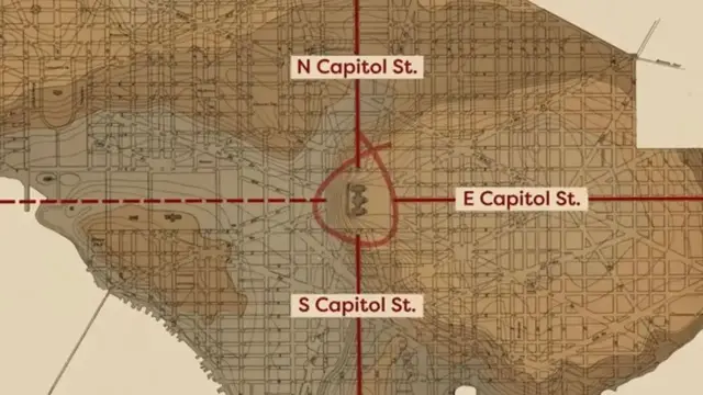
But all this laid the foundation for the city that we see today. So let's look at the map a bit closer. This one shows the difference in elevation of the city
4:18
where these brown parts are the highest. And this is where the Capitol building is
4:22
It sits on a hill that LaFont called a pedestal waiting for a superstructure
4:28
It serves as the anchor of the street plan. The streets that intersect the Capitol
4:33
are called Capitol Street. Makes sense. But are prefaced with North, South, or East
4:38
These divide the city into four sections or quadrants. The Northwest Quadrant is where most of the tourist sites are
4:45
So if you visit, this is probably where you'll spend most of your time. Georgetown is right here
4:51
And like I said, this was a city before DC. So the oldest building in the district is right here
4:57
The old Stone House. Because a lot of countries have their embassies along the street right here
5:03
This is known as Embassy Row, which is really cool to see. A large portion of this northwest section is Rock Creek Park right here
5:12
There's tons of public access like picnic areas, historic sites, and even a zoo
5:21
For addresses, you have to include the quadrant because look at this. There are two A streets right here going east to west But this is A Street Northeast and this is A Street Southeast These streets continue to work their way out alphabetically throughout the city
5:38
Then there are two First Streets going north to south. Same thing with the quadrants
5:43
This is First Street Northwest, and this is First Street Northeast. In addition to these, you'll notice
5:52
that there are these roads that break the grid. Most of these are named after different U.S. states like Massachusetts Avenue right here
5:59
or Pennsylvania Avenue, which connects the White House and the Capitol building
6:04
This has long been home to parades, protests, and marches. At the center of the map is this massive park
6:11
This is called the National Mall. Before the creation of New York's Central Park
6:15
this was the largest governmentally administered green space in the United States
6:20
In the center of this lies the now-completed Washington Monument. In fact, this mall is the epicenter for a lot of the major monuments
6:27
The Lincoln Memorial sits right here, opposite of the Capitol. And lining the mall are loads of museums, mostly belonging to the Smithsonian
6:35
Just south of the mall is this tidal basin, where the Jefferson Memorial sits
6:39
And no longer in the boundary of D.C. is this area right here
6:44
This is Arlington Cemetery. This house on the property used to be the home of Robert E. Lee, a military general that supported slavery
6:51
As soldiers died fighting the Civil War, many were buried in front of his house as a sign of the blood on his hands
6:58
This was the beginning of the largest cemetery for soldiers in the United States
7:03
And the city's designer, Pierre Lafont, is buried here. D.C. has a lot going on and is packed with history, and I hope that this is a good start to get you oriented
#Tourist Destinations
#Tourist Destinations
#Travel Guides & Travelogues