Up next in 10


Learn more about Bright Trip at https://brighttrip.com/courses
===== MUSICBED CONTEST =====
Competition time!
This June make a vertical video about your city or travels with the free Musicbed playlist and tag #BrightTripMusicbedChallenge
Go to http://brighttrip.com/musicbed-challenge and send us your video. You can also get full access to Musicbed by using code BRIGHTTRIP23 for 1 month off of an annual subscription for this challenge and any other films/projects you’re working on.
===== CDMX TOURS =====
Vibe Adventures is an impact travel marketplace for authentic, unique, and responsible local tours. Check them out at https://www.vibeadventures.com
CREDITS:
Executive Producer: Andrew McGarrity
Head of Partnerships: Max Savard
Script: David Gordon
Videography: David Gordon
Post: David Gordon, Driaan Louw
Stock Footage: Envato
Stock Music: Musicbed
Show More Show Less View Video Transcript
0:00
Mexico City is vibrant
0:10
History lives and breathes in the streets and buildings of Ciudad de Mexico
0:26
So let's take a look at the story of Mexico City and see how it became the mega metropolis it is today
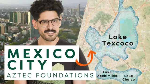
0:44
Mexico City sits on top of the lake bed that used to be Lake Texcoco
0:50
Centuries ago, this area was a series of lakes. Lakes Chalco and Xochimilco were freshwater lakes
0:56
while Lake Texcoco was sailing, providing its inhabitants edible flora and fauna
1:03
The lakes were located on the high south-central plateau in the Valley of Mexico
1:07
which is a part of the Trans-Mexican Volcanic Belt, sitting at around 2,000 meters or 7,000 feet in elevation
1:16
This region has been occupied by civilizations for thousands of years, such as the empire of Teotihuacan and later on the Toltecs
1:26
Some of the last indigenous people to move here were the Mexica, who eventually became known as the Aztec
1:34
The term Aztec comes from the Nahuatl word Azteca, which means people from Aztlan
1:43
So Aztlan is the place where the founders of Tenochtitlan and the Aztec empire came from
1:49
There is no evidence to prove whether Aslan was purely mythical or it actually existed
1:54
This is a 16th century map called Mapa de Sigenza, which depicts the journey of the Mexica from Aslan to the founding of Tenochtitlan
2:02
The legend goes that Huitzilopochtli, the god of sun and war, visited a Mexica leader in a dream and told him that wherever they saw an eagle
2:10
perched on a cactus with a snake in its beak, that's where they were to settle and build
2:14
This prophecy came true on an island in the middle of Lake Texcoco
2:18
And that's how Tenochtitlan was found in 1325. That same image is on the shield of the modern-day Mexican flag today
2:29
By the early 16th century, Tenochtitlan grew to an area of more than 13 square kilometers, or 5 square miles
2:37
The city was built on two islands, which were extended using chinampas, rectangular artificial islands
2:43
Often referred to as floating gardens, chinampas provided a plethora of vegetables such as squash, chilies, greens, various herbs, and maize
2:53
Around the chinampas were waterways that fed the gardens and were used for transportation
2:59
There were five major causeways leading in and out of Tenochtitlan. to the north to Tepeyac and Tenayuca
3:06
to the east to Tlacopan and Chapultepec, and to the south to Iztalapan, which also connected to Coyoacan
3:15
Coyoacan means place of coyotes, and today is the famous bohemian neighborhood where Frida Kahlo lived
3:22
All causeways led to the center of the city where the Templo Mayor sat
3:27
and divided the island into four calpulis, or neighborhoods. These neighborhoods surrounding the religious and governing square of the city created the basic layout that would become the seed of modern day Mexico City
3:44
In 1519, Hernan Cortes lands on the Yucatan Peninsula with about 630 men, most of them
3:50
armed with only a sword and a shield. And while you know this part of the story, Cortes in his power hungry pursuit plots with
3:57
neighboring city states and with the help of disease eventually destroys and takes over Tenochtitlan
4:06
This is one of the earliest known maps of Mexico City as the capital of New Spain
4:11
It's called the Mapa Uppsala and it shows how the city began to change under Spanish rule
4:16
Mainly causeways that previously led to the Templo Mayor were turned into roads
4:20
Aztec temples and sacred works were replaced by Catholic churches and just for good measure
4:24
they added Spanish counterparts to most of the Nahuatl names, like San Miguel de Chapultepec
4:30
But nonetheless, the basic layout, function, and way of life of Tenochtitlan remain the same in
4:35
New Spain. Barbara Mundy explains this in her book, The Death of Aztec Tenochtitlan
4:42
The Life of Mexico City. Highly recommended if you want to learn more
4:47
Mexico City became a hub for the global empire of the Hasberg kings. It held the seats of
4:52
Viceroyalty of New Spain and of the Archbishop, making it the center of colonial activity in the
4:57
Americas. By 1560, Ciudad de Mexico had a university, the printing press, and large buildings and
5:06
churches. A lot of mansions and palaces were built around the city center, beginning a trend that
5:11
would eventually give the name the City of Palaces. As of 1585, the city officially became known as
5:20
Ciudad de Mexico. This is a map from 1628. The city we see here has now expanded with hospitals
5:28
schools, parishes, and palaces. And you can still see waterways running through the mainland and
5:34
aqueducts running from the outside, but their function wouldn't last long because a crucial
5:39
thing about Lake Texcoco is that it sat at the lowest elevation of all the lakes. This wasn't an
5:44
issue for the harmonious engineering of Tenochtitlan, but for a growing Ciudad de Mexico, it meant a
5:49
continuous flooding problem. This is a city plan designed in the year 1793 and we see quite a jump
5:58
here from the map of 1628. The aqueduct and causeway lines of Tenochtitlan are now shown as calzadas
6:03
or roads. There is no reference to the lake and urban sprawl is now organized into cuartels or
6:10
sectors. Spanish vice royalty lasted until the early 1800s. Miguel Hidalgo's Grito de Dolores
6:17
sparked a 10-year war for independence that resulted in the Treaty of Córdoba
6:22
which established Mexican independence from Spain. So New Spain became organized as the first Mexican empire
6:29
A federal republic was declared in 1823 and a constitution codified in 1824
6:34
This constitution created the federal district around La Ciudad de México. Hey, I just want to take one quick minute away from the magic of Mexico City
6:44
to thank MusicBed for sponsoring this video. MusicBed has a curated roster of over a thousand authentic artists
6:51
with over 40,000 songs available for licensing. We use MusicBed at BrightShift all the time
6:56
because they make finding the right songs easy with tools that are built with filmmakers and creatives in mind
7:02
And speaking of creatives, I'm also very excited to share with you that we're partnering with MusicBed
7:07
to bring you a special short-form video contest. Using your own videos from wherever you live or anywhere that you traveled in the world We want to challenge you to get creative using a free Musicbed playlist that just for you and just for this contest All you have to do then is post your video tag Bright Trip and Musicbed so we know you submitted
7:24
and you're in. I know so many of you have tons of videos from traveling and vacationing and
7:29
adventures on your phone and it's just sitting there. So why not create something and in the
7:36
process maybe win some cool prizes. The winner will also be featured on this YouTube channel
7:40
and on Brightchips Instagram page. All the details are in the link in the description
7:44
The contest does end at the end of the month so go check it out and go check out Musicbed
7:49
because they're awesome. Let's get back to it. The latter part of the 1800s saw more revolution
7:54
political reform, and foreign intervention. The second Mexican empire was implemented by the
8:00
French and ruled by the Archduke of Austria, Maximilian I. Maximilian arrived in Mexico City
8:06
in 1864 with his wife Charlotte of Belgium to live in the Castillo de Chapultepec
8:13
This castle was originally built during Spanish viceroyalty, but Maximilian made several updates that gave the structure its neoclassical features
8:24
So this is the edge of Castillo de Chapultepec, and as you can see behind me
8:29
this long stretch that goes out is Avenida La Reforma. Avenida La Reforma was also built by Maximilian
8:38
in order to connect his home at the Castillo de Chapultepec with the city's main square
8:44
Maximilian was executed by firing squad under the command of President Benito Juarez
8:49
Benito Juarez was in power for 14 years. After him came a 30-year period now known as the Porfiriato
8:56
The Porfiriato was a big push towards the modernization of Mexico City
9:00
With a strong French influence, Mexico City's architecture bloomed. The infamous Palacio de Bellas Artes
9:08
was constructed at this time, as well as numerous mansions and monuments
9:13
Today, the Greater Mexico City area consists of 16 municipal boroughs and over 2,000 colonias
9:20
Most of the historic landmarks, attractions, and neighborhoods of Mexico City that you'll wanna visit
9:25
are located within these three boroughs, Benito Juarez, Coyoacán, and Cuauhtémoc. Within Cuauhtémoc is the historic center of the city
9:33
known as El Centro. This is the Plaza de Constitución, better known as El Zócalo
9:41
El Zócalo holds the National Palace, the Metropolitan Cathedral, and the ruins of the Templo Mayor
9:47
This is the ancient heart of the city from where the rest of the city grew from
9:54
To the south are the boroughs of Tlalpan, Milpa Alta, and Xochimilco. Coyoacán and Xochimilco both have neighborhoods with
10:02
the same name within their respective borough. The borough of Coyoacán is home to the National
10:08
Autonomous University of Mexico. Its main campus, Ciudad Universitaria, was the largest single
10:13
construction project in Mexico since the Aztecs. It holds a plethora of museums, theaters, and sports
10:19
facilities, including the 1968 Olympic Stadium. Less than 10 miles southeast from here is
10:26
Xochimilco. Xochimilco is the site of the last remaining cs and chinampas from
10:31
the pre-Columbian era. For that reason, it's a popular tourist attraction where
10:35
you can float down the cs on these colorful boats called trajineras
10:41
To the north of El Centro, in the borough of Gustavo Amadero, is another remarkable
10:46
site of Mexico City This is the Villa de Guadalupe which houses the Basilica of Our Lady Guadalupe Both sit at the foot of the Tepeyac Hill where it is believed the Virgin Mary appeared to Juan Diego on his cloak or apron
10:59
Juan Diego was a peasant who became the first Catholic saint to come from American indigenous descent
11:04
Today the basilica has one of the largest pilgrimages in the world with 20 million annual visitors
11:09
Connecting Mexico City's boroughs are a series of roads that circle and cut through the city mass
11:18
Surrounding the central neighborhoods of Mexico City is this freeway loop called the
11:22
Circuito Interior. It runs for about 42 kilometers or 26 miles and is technically not one continuous
11:30
freeway but rather an aggregate of smaller highways and boulevard sections. This outer
11:35
beltway works the same way. It's called El Periférico, which means periphery. The southern
11:42
section of El Periférico is known for its two-level highway systems that were completed in the early
11:47
2000s. This is Avenida Insurgentes, the longest road in all of Mexico City. It runs for about 29
11:56
kilometers or 18 miles. Insurgentes also has Metrobús station platforms along its center spine
12:03
It's one of the city's main arteries connecting the southern and northern neighborhoods with the business district
12:11
Along with the Metrobús, Mexico City has an extensive underground metro system and it's the city's most used form of transport
12:19
In total, it's composed of 12 lines and 195 stations that stretch 140,000 miles of track
12:26
Lines are designated by a number or letter and a color. Stations are named after landmarks, historical figures, events, or geographical locations
12:35
And one of the coolest things about the Mexico City metro is that each station has a designated logo that goes with its name
12:43
For this reason, riding the metro in Mexico City is a window into the city's history
12:48
Look at this map of the metro. Lines 1, 2, 3, 8, and B all thread around the Zócalo
12:55
the same way that the aqueducts of Tenochtitlan did around the Templo Mayor
12:59
Mexico City is a special place
13:11
It has a unique cultural identity that's grounded in its Aztec foundations
13:15
as well as a mix of international influences. Its people are kind, helpful, and extremely hardworking
13:25
It has all of the perks of a giant metropolis. so it has night scenes and amazing parks and museums and rich neighborhoods
13:34
and just so much to see. It's a city that very much feels alive
13:43
Whether you're into food, history, music, art, architecture, Mexico City has something for
13:50
everyone. It's a metropolis that is comparable to any other city in the world
13:57
So don't just take it from me. Go to Mexico City and find out for yourself
14:05
Huge thank you to Vibe Adventures. None of this would have been possible without your help and guidance
14:10
If you're looking for tours in Mexico City or other parts of Mexico, check out VibeAdventures.com
14:16
They have what you need and they are kind, smart people
#Tourist Destinations
#Tourist Destinations
#Historical Sites & Buildings
#Travel Guides & Travelogues