Up next in 10


There is no other city that began the way Salt Lake City did. The map of Salt Lake City may look like a simple grid but there's actually way more to this famous Utah city map.
You may know it from the fear factor haunted house episode (featuring the famous Nightmare on 13th haunted house) or the real housewives of salt lake city but probably don't know the most interesting thing about Salt Lake City, its history.
Learn more about Bright Trip at https://brighttrip.com/courses
Leave a comment with any questions you have and we’ll make sure to include it in a future video.
Make sure to subscribe to the channel to learn how to travel smarter.
===== FOLLOW ON SOCIAL =====
Bright Trip Newsletter: https://mailchi.mp/brighttrip.com/signup-form
Bright Trip on IG: https://www.instagram.com/bright.trip/
Bright Trip on Pinterest: https://www.pinterest.com/brighttriptravel/
Bright Trip on Facebook: https://www.facebook.com/BrightTripTeam
Bright Trip on Twitter: https://twitter.com/trip_bright
===== ABOUT BRIGHT TRIP =====
Show More Show Less View Video Transcript
0:00
Let's freaking do this
0:00
Long time freaking coming, huh? Beautiful Salt Lake City has become the scenic and industrial center of the Intermountain West
0:08
There is no other city that began the way this one did. And the reason it was founded is reflected in the geographical layout of the streets themselves
0:17
One could look at how different cultures organize the territorial environment to communicate how it relates to their concept of the universe
0:25
If you look at a map of Salt Lake, it's easy to look at it and just assume that it's a simple grid
0:29
but there's actually a lot more going on here. So what is the reason Salt Lake looks like this
0:42
This region of the Americas has been home to several groups of indigenous people forever
0:47
And in 1847, this is what the United States looked like. And right here is Salt Lake City
0:53
This area was Mexico. And the reason I bring up the year 1847 is because that is the year a group of Mormon pioneers
1:04
traveled west across the entire United States and settled in the Salt Lake Valley
1:08
For this, I talked to Stephen Olson, who is the senior curator of the Church History Library in
1:13
Salt Lake City. They felt like this setting was particularly ideal for the establishment
1:19
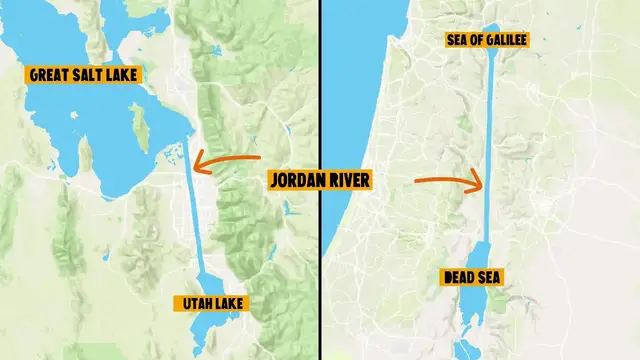
of this new homeland. They found that there was a salt sea that was connected with an inland lake
1:25
by a single major tributary. So they called that river the Jordan River after the Holy Land in
1:32
Palestine. It was seen as the og to the Dead Sea in the Holy Land. We're going to dive into a
1:38
little bit of history, but I promise this is applicable to the layout of the map. We're getting
1:43
there. Sure, they settled in Mexico, but the writing was kind of on the wall that this was
1:48
going to become the U.S. Okay, writing on the wall is a little bit of a broad stroke. 1847 was the
1:54
middle of the Mexican-American War, which was a dispute over land that ultimately led to the U.S
2:00
acquiring a large portion of the western United States. So don't comment about that because I can
2:06
see you typing that comment right now and it is corrected. Back to the video. So enter Brigham Young
2:13
Brigham Young was the leader and prophet of the LDS Church, formerly known as the Church of Jesus
2:17
Christ of Latter-day Saints and often referred to as Mormons. And this is where the story gets really interesting because there was always a friction between the US government and the LDS settlers Up to this point the members of the church had not been received well in the various cities that they relocated to So by settling here Brigham Young hoped to build
2:36
enough power and autonomy that they could have their own territory and live freely how they wanted to
2:42
Being apart from the rest of secular society, he felt like there would be a greater opportunity
2:48
to establish this millennial ideal. So at this point, the church organization
2:52
was only about 20 years old. The LDS church had tried to create several settlements that had, for one reason or another, failed
2:59
To create on earth an ideal society that mirrored that in heaven
3:04
That included not just how people behaved, but how they were organized as a society
3:09
Brigham Young's predecessor, Joseph Smith, had created this. This is the Platte of Zion
3:16
The plan laid out perfect square blocks with wide, straight streets laid in the cardinal directions
3:22
north, south, east, and west. One thing that will come into play is that this plan didn't really leave much space for government buildings
3:29
So the whole community was intended to be consecrated unto the Lord
3:34
In fact, these buildings were all called House of the Lord. So when they got to Salt Lake City, this is exactly what Brigham Young set out to do
3:41
He was really intent on replicating here what Joseph Smith had tried but failed to do in the United States
3:48
But if you look closer at the map, you'll notice this isn't a perfect replication of the Platte of Zion
3:53
but it's a whole series of grids. So let's start with the first plat
4:05
that was modeled after the Plat of Zion right here. At the center of this is Temple Square
4:09
a whole block dedicated to the temple. Keep this in mind because it's from this spot
4:15
that every other street name is determined, meaning if you go one block east of here
4:19
you'll be at 100 east. Two blocks east will be 200 east, and so on and so forth
4:25
Something about these plats is that a perfect square grid does not fit very well in the real world
4:31
And so, like, specifically, you run into large hills in the north and east
4:35
and not to mention the mountains that you can't build on top of. And so the grids start to break apart
4:39
So a year after the LDS settlers, which I'll call the Saints, came to this area
4:44
this land was officially acquired by the United States. Brigham Young petitioned to have this entire area and they called it the state of Deseret
4:52
and included all of the Great Basin and the Colorado River drainage area He was denied this massive plot of land but was designated this area which is the territory of Utah The federal government wasn gonna
5:05
give the Mormons that much credibility. This is where the ideal future for the saints
5:09
began to clash with the ideal future for the federal government of the United States
5:15
Look, I know this is like pretty political right now, but I promise this is interesting
5:20
and I promise that it has to do with this map. The saints were doing great. They were living in this theocracy they wanted
5:26
Brigham Young was the governor of the territory of Utah. They had designed their own currency
5:31
They could practice polygamy. They were building their temple and they had their own militia
5:35
Things were going really well. This might've been because the United States
5:39
was a little bit distracted by something that was happening at that time, the Civil War
5:43
So as soon as the Civil War is over and the United States has a little more attention
5:47
to pay to those settlers in the Salt Lake Valley, two major things happened that led to the Salt Lake City
5:52
that exists today. The first of these was the completion of the transcontinental railroad at
5:59
Promontory Point in 1869, which wasn't even 50 miles from Salt Lake City. This was a major concern
6:05
for the saints because they had been enjoying relative isolation, but this new railroad would
6:10
mean the import of non-Mormon goods and people. One of their responses to this was ZCMI, which
6:16
stands for Zion's Cooperative Mercantile Institution. Essentially, this was the first department store. The building for ZCMI was placed just a block south of Temple Square
6:26
and the facade of it still exists today as part of a larger mall called City Creek Mall
6:32
The second of these issues is really more a culmination of issues that happened as the
6:36
federal government came into a city that was set up by a religious group and tried to impose their
6:42
laws and standards of urban design onto this already existing functioning society. If it's
6:49
any indicator of this friction that existed, the territory of Utah was one of the first territories
6:54
but the state of Utah was one of the last states. And a major part of it is that the government sent
7:00
in a military to keep an eye on this group. So if you look at this map, you can see this large area
7:05
on the eastern side of the city. Today, this is mostly the University of Utah, but it's also Fort
7:10
Douglas, which is this fort that was built to monitor those saints. So as time went on and
7:15
compromises were drawn on either side, there was a very conscious decision to build the federal
7:20
buildings outside of this religious city center and away from Temple Square to create a separation of church and state So let look at this map Here is Temple Square North of here is where the Capitol Building was built on Capitol Hill
7:34
South of here is where City Hall was built and east of here is where Fort Douglas lies
7:39
On the west end there's a series of railroad depots which brought people from the outside
7:44
here and over time radically changed the tenor of Salt Lake City society
7:50
So here are these four secular institutions that kind of ring the traditional settlement
7:56
of Salt Lake City. And if you know that part of the history, the locations of those buildings become all
8:02
the more interesting. Okay, so we've covered all of the political, historical elements of this, let's just look
8:08
at a couple parts of this map. Plat D right here is commonly referred to as the avenues
8:13
These are the foothills of the mountain and the grid here is much smaller designed for
8:17
residential houses. And as soon as you get south of 900 South, the grid system is much different
8:25
These were designated to farming. It's often said that the streets here were designed to be wide enough for horse and carriage
8:31
to turn around in without any issues. I haven't confirmed that that's true, but that's a general accepted lore of the urban
8:38
design of Salt Lake City. I want to point out this park right here. This is Liberty Park
8:43
This is land that used to belong to Brigham Young that he gave to the public. and this is home to one of the oldest aviaries in the nation
8:50
In the past years, the population of Salt Lake City has been booming
8:54
Some old buildings have been going down and a lot of new buildings are going up
8:59
A new airport recently opened and is still being built and the Great Salt Lake is depleting and evaporating faster than ever
9:07
The city has continued to evolve and grow and has hosted the Olympics. The Olympic flame is now passing Temple Square in downtown Salt Lake City
9:16
There's a million other things that I could talk about, about Salt Lake, but this is just
9:22
an intro to why the streets are laid out the way they are. If you found this video interesting, please like and subscribe
9:28
At Bright Trip, we create a bunch of content that helps travelers travel smarter and understand
9:33
where they are. So if you're interested in that, there's a lot of free content on our website, which
9:37
is linked in the description, brighttrip.com, and we'll see you over there
9:42
It's hard to get lost in Salt Lake City because you always have these dominant orienting devices
9:49
that help you know where you are, not only with respect to the landscape, but also with
9:54
respect to the universe
#Tourist Destinations
#Tourist Destinations
#Historical Sites & Buildings
#Travel Guides & Travelogues