Up next in 10


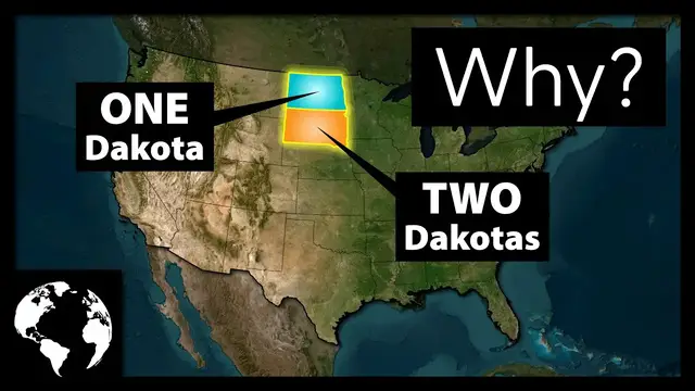
The United States has two Dakotas: North Dakota and South Dakota. But while these are two completely separate states each with their own state governments, two U.S. senators, and representative in Congress, there's nothing really all that natural or cultural that necessitated the area be split into two. Here's why the formerly single Dakota territory was split into two separate states.
Show More Show Less View Video Transcript
0:00
North Dakota and South Dakota, two separate Dakotas for a single connected piece of land
0:04
within a single country. At one point, these two states were a territory simply and sufficiently
0:09
named Dakota until they were split up right before getting statehood. And this has had
0:13
reverberating impacts for the United States as a whole. Here's why there are two Dakotas instead of
0:18
just one. Welcome to Geography by Jeff. Have you ever wondered why the United States has two Dakotas
0:27
Probably not. For as long as you and I have been around, there's always been a North Dakota and a South Dakota
0:33
But there was nothing natural that split this territory in two. At one point, these two states were combined into a larger territory
0:39
Today, of course, that's no longer the case. And we're going to explore exactly how that happened in today's episode
0:44
But before we get into why the United States has two Dakotas, as usual, be sure to check out the What If Geography podcast that I co-host with geography professor Hunter Shobie
0:52
If you enjoy geography and deep dives into complicated subjects, this is the podcast for you
0:57
New podcast episodes premiere every Wednesday and you can get them right here on YouTube, Spotify, Apple Podcasts, or wherever you get your podcasts
1:07
Before we get into the specifics of North and South Dakota, it's worth getting into a bit of
1:12
historic geography around how the United States expanded westward and how territories became
1:16
states in the first place. Shortly after the conclusion of the United States War for Independence
1:21
the U.S. was left with quite a bit of land that wasn't inhabited by citizens of the new country
1:25
They were inhabited by a lot of Native American tribes, of course, and it's worth highlighting that these tribes would be systematically and brutally removed over the coming decades
1:33
But over the next 100 years, the United States would grow from a relatively small area restrained to the East Coast
1:39
to encompassing basically the entire United States we know today. And as the United States grew, it had a fairly formulaic process by which it would organize the new land
1:48
The United States would send out a survey team to assess the land and, once complete, the land would be more formally organized into a territory
1:54
These territories would have some form of territorial government, but otherwise would not have all the same rights and privileges of an official state
2:00
Now, territories could be all manner of sizes and proportions when they were formed. The Northwest Territory, for example, included the modern-day states of Ohio
2:08
Indiana Illinois Michigan Wisconsin and parts of Minnesota The Oregon Territory included the modern states of Oregon Washington Idaho and parts of Montana The point being that the way in which territories were originally organized was rarely the form they would continue with into statehood And the
2:23
primary reason for why a territory would be split up upon entering the country as a formal state
2:27
was largely due to where and how the population that moved there was dispersed. As people moved
2:32
into an area and cultivated the land, eventually, with enough people, they would request to be
2:37
admitted into the country as a state. This was because they wanted those same privileges that
2:41
other states got. And in order to do this, it required both houses of Congress to pass
2:45
If one area of a territory was much less populated or geographically isolated
2:49
in order to make for a better argument for statehood, the people formally requesting admittance would only request a smaller area become a formal state. This largely occurred
2:57
with many of the states we know today. Oregon and Washington, for example, were split at the
3:02
request of the then Northern Oregon Territory that felt like Oregon didn't represent their
3:06
interests. At which point, only Oregon was admitted into the Union as a state. But while
3:11
this was a common method for why a territory would be split up prior to entering, another method would
3:15
boil down to one simple thing, politics. The current US state boundaries feel so permanent
3:20
because we've all grown so accustomed to them within our maps and books. By the time that they
3:24
were formed, most state boundaries were pretty arbitrary and, more often than not, politically
3:28
motivated. But before we get into how North and South Dakota came to be specifically, if you're
3:33
enjoying this video, hit that subscribe button. More fun geography videos are just a single click away
3:42
As we've already established, in the middle part of the 1800s, there was an enormous push for
3:47
settlement in the West by the US federal government. This, of course, came with the
3:50
creation of new train routes to move people and goods quickly and efficiently to the country's
3:54
newest territories. Unfortunately, during this time, train routes weren't often built going
3:59
north and south within these new territories. The goal was always to connect people with
4:03
population hubs back east, not with other population hubs in the frontier, which to be fair
4:08
any population hubs in those days were rather small, so there was little reason to spend big
4:12
on rail to connect them. In the case of the Dakota Territory, it had two primary rail routes moving
4:17
through it. In the north, a train connected to Minneapolis by way of Fargo. In the south
4:22
a train connected to Chicago by way of Sioux City That might not seem like a big difference today but remember back in the 1800s Minneapolis was a relatively small agrarian city whereas Chicago was the big metropolitan city for the region With far more movement between these two regions to the northern and southern parts of Dakota
4:38
respectively, it's not that surprising that differences began to emerge between the two
4:42
sets of people. And as with any region, there are bound to be differences in how each are settled
4:46
and managed. In this case, the northern portion of the new territory began developing in a more
4:51
rural fashion than the southern half. Cattle ranching, fur trading, and far more agriculture
4:55
permeated the northern portion of the territory, whereas the southern part was more populated and
4:59
far more urban oriented. Nothing like New York City or Chicago, of course, but certainly more so
5:05
than the north. This started the original cultural deviation between what would become the north and
5:09
the south. But the differences between the two halves of Dakota weren't just based on cultural
5:13
opinions. There were tangible aspects at play as well. The southern part of Dakota had a population
5:18
roughly three times the size of its northern half, and those in the south desire to become
5:21
a full-fledged state given that they met the population requirements beset on them by the
5:25
federal government at the time. While everything we've covered is important cultural context and
5:33
builds to an inevitable split, the real reason why we have two Dakotas today is something far
5:38
more superficial. During the mid-1800s, there was a bit of a land rush in terms of getting
5:42
territories converted into full states, and if you were the party that was in control at the time
5:46
you had considerable power to shape whether you were going to allow a new state that would vote your way or not
5:51
In the case of the Dakotas, the president at the time was Grover Cleveland, a Democrat
5:56
And in 1888, President Cleveland proposed admitting four new territories as states
6:00
Montana, New Mexico, Dakota, and Washington. His logic was the former two states would vote Democrat, and the latter two would vote Republican
6:08
And therefore, it should be an easy pass within a split Congress. Unfortunately for Cleveland, later that same year, Republicans gained majorities in both
6:15
the House of Representatives and Senate, which changed the equation quite a bit
6:19
In order to get ahead of the possibility that a Republican-led Congress would only admit Republican territories into the Union, congressional Democrats cut a deal with Republicans to
6:27
allow for Montana and Washington into the Union, but not New Mexico. And, of course, given that there had already been multiple attempts to split the Dakota
6:34
territory prior to this moment, Republicans seized on the opportunity to admit not just
6:38
Dakota but to split it into two territories and admit both at the exact same time All in all the Republicans managed to get three Republican states for the low price of admitting just a single Democrat state
6:53
Today, of course, we have two Dakota states, North Dakota and South Dakota
6:57
and they are very similar to each other. There are some minor differences here and there, but largely within the context of the United States
7:03
they're basically the same. This is perhaps not all that surprising, given that the two states are literally right next to each other
7:09
but it can't be understated that the Dakota territory was split up for political reasons
7:13
not natural or even cultural ones. Both states are very similar in size. North Dakota is about
7:18
71,000 square miles, and South Dakota is about 77,000 square miles, making them the 19th and
7:23
17th largest states respectively. If we pulled the two states together, they would become the
7:27
fourth largest state by just a few hundred square miles, behind Alaska, Texas, and California
7:32
and almost exactly equal with their neighbor Montana. Additionally, both are fairly rural
7:36
even to this day. North Dakota's largest city is Fargo, which has about 252,000 people within the
7:41
entire metro area. And South Dakota's largest city is Sioux Falls, which has about 282,000 people
7:47
In total, each state only has three U.S. Census Bureau-defined urban areas with a handful of
7:52
urban clusters. This leads to North Dakota as being about 40% rural, and South Dakota at about
7:57
43% rural. To put this in perspective, the U.S. rural population stands at about 20%
8:03
And not only are both states heavily rural, but they're both very conservative in their politics
8:08
As of today, both states have a Republican governor and lieutenant governor. Each state's two U.S. senators and single U.S. representative are both Republican
8:16
And both states' legislators are heavily dominated by Republicans. On a political level, the two Dakotas look exactly alike
8:22
Finally, even the two states' climates are fairly similar, though North Dakota can get quite a bit colder
8:28
All this is to say, had North Dakota and South Dakota started out as a single state
8:32
there likely wouldn't have been anyone suggesting it should be two states today. The Dakota Territory probably should have been admitted as a single state
8:39
but as the saying goes, all's fair in love and war. In this case, the Republican Party was able to shrewdly get two states in the place of one
8:47
much to their great benefit in Congress today. I hope you enjoyed learning more about the Dakota Territory and how it came to be two separate states
8:54
If you did, please subscribe to my channel. And if you want to watch more of my videos, you can do so here
8:59
Thanks for watching. See you next time
#education