Up next in 10


Follow me on Twitter: https://twitter.com/GKonYoutube
In this video I talk about old maps which depicted parts of the world incorrectly.
Become a member on Patreon & get exclusive content! https://www.patreon.com/generalknowledge
Join the Discord Server: https://discord.com/invite/f4neAVWZfF
Business Contact: [email protected]
Thanks for watching, remember to subscribe to catch future videos!
Show More Show Less View Video Transcript
0:00
Sometimes when we look at old maps, we spot tiny mistakes. An island that's slightly too big
0:08
or a coastline that isn't that accurate. Excusable and understandable mistakes from
0:14
maps that were often done with complex mathematical formulas, and long before the
0:18
time of satellite images that allow modern map makers to be 100% accurate. But there's also
0:24
another type of errors that old maps have, arguably less excusable, because they weren't
0:30
based on a technological limitation, they were, for a good part, based on hearsay
0:36
Someone heard about something existing in some place and in some specific manner, and
0:41
someone made a map of it. It's important to note that many of these don't qualify as major mistakes that every
0:48
map of a specific time had. Sometimes they were literally a single map that depicted something that ended up being
0:54
wrong. And perhaps even at the time, there was enough skepticism at the lack of evidence
1:00
to make it a universal mistake in all contemporary maps. In this video, we're going to take
1:05
a look at a few of those mistakes. What they were, why they were made, how far the mistake
1:10
got and what it would mean if those maps were in fact correct
1:14
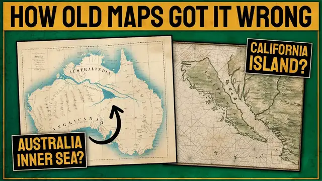
Starting with the ones on the thumbnail, first, California Island. In 1510, a Spanish book
1:20
called Las Sergas de Esplandian, road of a land of no men, inhabited only by women
1:26
This land would be an island called California and located off the west coast of North America
1:32
This myth even encouraged a wealthy Spaniard to embark on a voyage to find the island
1:38
in similar fashion to the many expeditions to the mythical city of El Dorado in Southern America
1:44
Despite contradictory reports from explorers of the region, California continued to be depicted as an island on maps until 1747 when King Ferdinand VI of Spain
1:55
was forced to issue a decree that California is not an island, based on real exploration by
2:02
Spanish officers and not some book of mythical tales. If California was in fact an island
2:08
it raises the question of what would have happened to it from a political point of view
2:11
Would it have remained a part of Mexico? Would it still be a part of the United States
2:16
or would it be its own independent country today? Then, the river and lake that ran through the middle of Australia
2:22
In the 19th century, Australia was mostly unknown and therefore unmapped. And there were some projections, for whatever reason, and perhaps only wishful thinking
2:31
that a large river basin and an inland sea existed inside the continent The logic apparently was if America had the Mississippi and the Amazon Europe had the Danube Africa had the Nile then somewhere within the vast continent of Australia there must be a big river
2:48
Early surveyors of the unexplored center and west of Australia kept on the lookout for a large body of water
2:55
possibly connected to the outside ocean somewhere within Australia, which would signify a vast territory of fertile lands, perfect for colonization
3:03
In 1827, former East India Company officer Thomas Maslin published this map of that inland sea in his book
3:11
The Friend of Australia, which provided instructions for surveying and exploring the island continent's interior
3:18
But the map was based on no exploration at all, and was merely a projection of what an inland body of water could look like
3:24
It took a few more decades for the explorers to realize that Australia's interior is in fact just dry and waterless
3:31
In the 19th century, the dead heart of Australia even became a way of describing the region
3:37
Oddly enough, after realizing the Inland Sea did not exist, a plan to create one started being made
3:43
The Bradfield Scheme, a proposed Australian water diversion scheme, was an inland irrigation project that was designed to irrigate and drought-proof
3:51
much of the western Queensland interior, as well as large parts of South Australia
3:56
being devised by Dr. John Bradfield. The project was abandoned in 1947, but recent proposals for water diversion and inland irrigation have been made in an attempt to make the Australian inlands more habitable and fertile
4:09
So who knows, this map mistake might eventually become a reality. One major map mistake were the West Indies, also known later as America
4:18
Since the earliest printed map to show the Americas was produced 14 years after Christopher Columbus reached the continent in 1492, for part of the duration of those 14 years
4:28
It was still believed by some that he had in fact reached Asia
4:32
Accordingly, this map shows North America welded onto eastern Siberia, with Cuba and Espaniola floating in the same sea as Japan
4:41
It was only later on that Europeans realized they had in fact discovered the existence of a brand new entire continent
4:48
In this map, we can see the overlay of the reality of the continent plus its distance to Asia
4:53
with what Europeans projected at the time. They seemed to be both unaware of the existence of the Pacific Ocean, believing those landmasses
5:00
were in fact part of Asia, as well as the existence of a Sipangu island, perhaps what
5:04
they thought was Japan. Eventually, with further exploration, they realized their mistake
5:09
Moving to Hopenigra. The Hopenigra, translated as Black Rock, is a phantom island, believed
5:15
to be a 33 Black Rock located at the magnetic North Pole or at the North Pole itself It attempted to explain why all compasses point to this location The idea came from a lost work titled Inventio Fortunata
5:29
and the island featured on maps from the 16th and 17th centuries, including those of Gerardus
5:35
Mercator. Gerardus Mercator, the famous guy who made maps and who he got the commonly used Mercator
5:40
projection from. Mercator even described the island in a 1577 letter. In the midst of the four
5:46
countries is a whirlpool, into which there empty these four in-drawing seas, which divide the north
5:52
It is 4 degrees wide on every side of the pole, that is to say 8 degrees altogether, except that
5:58
right under the pole there lies a bare rock in the midst of the sea, and it is all of magnetic
6:05
stone. It's a little surprising how someone like him would just base this off a random book. Perhaps
6:10
there were other accounts that justify his claim. Another mistake was Bermeja. Located in South
6:16
America, Bermeja was another phantom island. I think we can roughly translate it to red
6:21
perhaps in reference to what they thought the land on the island looked like. According to
6:24
futuremaps.com, which I used as a source for a few of these maps, the great Mexican mystery of
6:29
the island of Bermeja started in 1539, when it first appeared on Spanish maps. Its last appearance
6:35
on a map was in the 1921 geographic atlas of the Mexican Republic, reasonably late for a mistake
6:42
about a non-existing island. Although there is the low possibility that the territory did in fact
6:47
exist, being a very small island barely above sea level, which would have for some reason been
6:52
submerged in the meantime. Nobody really cared about the mistake until the 1980s when the Mexican
6:57
government thought that if it did exist, it might help them claim territorial waters that were rich
7:03
in oil. They began actually searching for it again, giving up in 2009 and concluding that the
7:08
island was in fact non-existent. I think this might be the longest lasting map mistake on this list
7:15
And one more was Terra Australis. Terra Australis, or the Great South Land, was believed to be a vast
7:21
continent, partially where Antarctica is. It was first mentioned by Aristotle in the 4th century BC
7:26
but oddly they had no idea Antarctica existed. They just conceived the idea that a large landmass
7:32
must exist there, for whatever reason. In 1520, Portuguese explorer Ferdinand Magellan recorded
7:38
siding land across from the southern tip of South America and believed it could in fact be
7:43
Terra Australis. Throughout the 15th and 17th century, Terra Australis featured on globes and
7:49
maps generally as a much larger landmass than Antarctica. However, by the late 18th century
7:54
James Cook failed to discover any sign of it on his travels around New Zealand
7:58
showing that a continent of that size couldn exist Belief in its existence began to decline from that point onwards until the actual discovery of Antarctica which despite matching the idea of a landmass
8:09
existing in the South Pole, wasn't nearly as large as the initially projected Terra Australis
8:15
Going back to what I mentioned at the start, one common mistake in early maps was scale
8:19
In this ancient map of Europe, we can see the wrong scale along all of these islands
8:24
This is a 15th century recreation of Ptolemy's world map. Now, I think we can attribute these
8:29
mistakes in scale to the inability of accurately measuring the size of territories, but I also
8:34
think there might be another factor. The purpose of these maps was likely not to depict size or to
8:39
help navigation, a change that only came at the time of Mercator's maps and the age of European
8:44
colonization. I'm sure map makers maybe had travelers in mind when they made their maps
8:50
And for that use, they would measure how much time their travels would take based on the size of territories
8:56
But maybe the main point of the maps was simply to show how the world was
9:00
and which territories existed in each area regardless of their size. If they wanted to make sure people knew about the existence of these islands
9:08
then they marked them on the map at a size in which they were absolutely visible and couldn't go unnoticed
9:14
Not to mention the tremendous mistakes that also exist in the depiction of the territory shapes overall
9:19
which can be attributed to the lack of technology at the time. I'm sure if we didn't have satellites or
9:24
many of the tools and technology we have today, we would have trouble making accurate maps as well
9:29
These old or even ancient maps are filled with these completely excusable and understandable mistakes, but they're still interesting to look at. Even Aqual maps
9:39
depicted the world as a flat circle with Africa, Asia, and Europe all connected and surrounded by a single ocean
9:45
ocean, something that was a trend in these very early maps. Al Idrisi world's map, commissioned by the king of Sicily in 1154, the famous Tabula
9:53
Rogeriana, where perspective is somewhat questionable, for instance the Adriatic sea stretching to
9:59
the north of Italy, or the straits of the Bosphorus being much longer than they in fact
10:04
are, not to mention, again, the disproportionate size of islands, and the fact that according
10:09
to him, Africa would stretch all the way around Asia in the south
10:12
Oh, and also this map was actually made upside down, some people say due to the influence
10:17
of Chinese cartographers. I'm not sure if that is in fact the reason, but if you know it, let me know
10:22
So those are a few of the places that old maps thought existed or just simple mistakes
10:28
that ancient map makers made in creating their depictions of the world that they knew
10:32
Do you know of any other map mistakes like these? Let me know in the comments. Thanks so much for watching this video
10:37
Subscribe if you want to catch future ones and I will see you next time for more general knowledge
#Fun & Trivia
#Hobbies & Leisure
#education
#Geographic Reference
#Maps
#Earth Sciences
#Other