Up next in 10



Watch the full version here: https://www.brighttrip.com/my-courses/berlin?utm_medium=ytberlinmap
Berlin Tour Guide Ryan Balmer:
@berlinreguided https://www.instagram.com/berlin_reguided/?hl=en
RESOURCES: https://interaktiv.morgenpost.de/so-alt-wohnt-berlin/
https://blogs.getty.edu/iris/building-divided-berlin/
https://www.notion.so/Berlin-Map-Explainer-edbd5e91b5dc4c4fa99f1eb3d8d6047f#c31c8607168c4400b1a4be45fa460d7a
https://www.slowtravelberlin.com/a-brief-history-of-tempelhofer-feld/
https://maps.arcanum.com/de/map/europe-19century-secondsurvey/?bbox=1435614.1216551277%2C6861630.767347558%2C1557719.15305885%2C6913381.0608671745&layers=158%2C164
https://war-documentary.info/soviet-memorial-in-tiergarten-berlin/
Leave a comment with any questions you have and we’ll make sure to include it in a future video.
Make sure to subscribe to the channel to learn how to travel smarter.
===== FOLLOW ON SOCIAL =====
Bright Trip Newsletter: https://mailchi.mp/brighttrip.com/signup-form
Bright Trip on IG: https://www.instagram.com/bright.trip/
Bright Trip on Pinterest: https://www.pinterest.com/brighttriptravel/
Bright Trip on Facebook: https://www.facebook.com/BrightTripTeam
Bright Trip on Twitter: https://twitter.com/trip_bright
===== ABOUT BRIGHT TRIP =====
Bright Trip creates video-based travel courses to help you travel smarter. From our location courses that visually demystify places like Tokyo, London, Costa Rica, or Cape Town to our skills courses that cover how to travel solo, with kids, or how to document your travels more effectively and efficiently - each course is created by real travelers, like you, and aims to create a community of curious travelers that are eager to travel smarter.
#brighttrip #travelguide #travelsmarter
Show More Show Less View Video Transcript
0:00
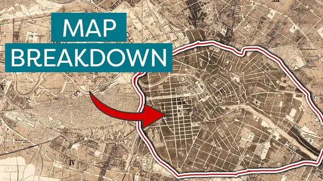
This is a map of Berlin from 1811, and this is Berlin today
0:03
On each you can see the Spree River that runs through the city, Museum Island, and Tiergarten
0:09
They're the same city, but this one is at the beginning of a massive explosion in population
0:14
And while they've both faced great destruction, for this one, the worst is yet to come
0:20
Berlin has been called a city condemned forever to becoming and never to being
0:25
Few cities have experienced the destruction Berlin has. But the events that scar this city are the same that have led to the vibrant Berlin of today
0:40
For the free full version of this video and for a whole guide on Berlin, you can go to
0:45
brighttrip.com which I have linked in the description. In this map of Berlin from 1811, you'll notice a zigzag line encompassing the center of the city
0:54
remnant of a fortress wall that once surrounded Berlin. You can see Museum Island in its center
1:02
This used to be called Kahn, with its sister city Berlin opposite the Spree. Also, I will say
1:08
I don't speak German, so pronouncing these things is really hard for me and I'm going to get it
1:12
wrong. So thanks for the patience on that. In 1650, and as a response to the Thirty Years' War
1:19
a fortress was built surrounding both of them that eventually led to their unification
1:23
Mostly gone by 1811, you can see its lasting influence on the layout of the streets
1:28
And today, only a faint reminder of it can be seen. After the fortress, the next phase of expansion for the city is marked by a replacement wall surrounding a larger area, the Berlin Customs Wall
1:40
This wall has a much larger impact on today's map of Berlin in several ways
1:44
Not only does its route remain relatively visible, but it's from the gates in this wall that many spots in the city get their name
1:51
In German, the word gate translates to Tor. And these are all named for the places the gate or Tor led to
1:59
Most famously, the one remaining gate is the Brandenburg Gate. Of this wall, only a small portion still stands, and even it has been reconstructed
2:09
This is a pivotal moment in Berlin's history. Because if this is 1811, look at what is about to happen in the population
2:17
This boom in population was a result of the Industrial Revolution, with people moving to the city to work in massive factories, some of which are still standing
2:26
Up until the 1860s, this old customs wall contained a majority of the city's development
2:31
but as the population grew, so too did the city limits. This came to a head in 1920 when the suburbs were annexed
2:38
expanding Berlin by 13 times and doubling its population from 2 million to 4 million
2:43
This city boundary is essentially the same as Berlin city boundary of today But amid all this growth mass destruction awaited Wait it actually starts before this
2:58
As Hitler rose to power, he wanted Berlin to be the capital of an area much larger than the contemporary Germany
3:04
But he didn't really like Berlin. He called it an unregulated accumulation of buildings and wanted to make some not-so-subtle changes
3:13
He planned a massive redesign of the city, followed by a name change from Berlin to Germania
3:19
The centerpiece would be a massive grand hall that could hold over 100,000 people at a time
3:24
This was to sit near where the Reichstag is, and the boulevard that would lead to it would be just as monumental
3:31
120 meters wide, it would lead to a grand arch. I sent a friend of mine, Ella, who is German and lives in Berlin
3:40
To help show us some of the things that we can't see on the map It's really cold and I'm freezing my fingers off
3:45
I've made it to the entrance of Tjagaten Behind me is the Brandenburg Gate, right there
3:52
I just passed through it And now I'm going to walk into this beautiful park
3:57
I'm supposed to be finding some curves on the sidewalk I haven't found them yet, but I'm going to keep looking
4:09
These ghost curbs are essentially all that remain of the road that would have been
4:15
Everybody's just walking by. Nobody's paying attention to these marks on the ground, even though they very clearly
4:20
look like the curb of an old sidewalk. But then it leads to the forest
4:27
Not much of his plan was ever realized, and only few remnants of it are visible
4:32
A Prussian military victory column was moved, the east-west road in Tiergarten was widened
4:37
and a place where the arch would stand sits this. This is the sch..
4:48
I've just made it to the Schwebelastungskörper. So I have made it to the entrance, and there's a sign here
4:55
It says, The Schwebelastungskörper bears witness to the biggest construction project Berlin has ever seen
5:00
planning for a gigantic project commenced in 1937 that was intended to completely redesign Berlin
5:08
This was built to see if the ground could support the weight of the huge triumphal arch that was
5:13
going to be here. It was planned to be way bigger than the Arc de Triomphe in Paris
5:18
The reason they had to test the ground is partly because of the same reason Berlin has so many
5:22
lakes and is so lush. This whole area is essentially a swamp. Look at this elevation map of Berlin
5:28
It's almost perfectly flat, which can make it hard to escape the water beneath
5:32
This dense 12 ton structure has remained basically because the effort of dismantling it is so hot It still stands and has been described as a silent monument to Nazi megalomania which
5:46
I think is just a perfect description for it. But the biggest effect this whole plan of Germania had on the city was the Nazis' destruction
5:54
of much of Berlin to clear way for it. But this destruction was soon overshadowed by what would happen during World War II
6:04
Berlin sustained so much damage from the war that nearly 80% of its buildings and structures near the city center were destroyed
6:13
It's honestly a miracle that the Brandenburg Gate still stands at all
6:18
Just look at it in the middle of all of these ruins. This is also true of Tiergarten
6:22
In all of these maps, you've been able to see it since it's been here since the 16th century
6:27
But it almost didn't survive the war. Heavily bombed, most trees and monuments were destroyed
6:31
Then during reconstruction, big portions of it were used for farming. Slowly, it was restored to the major piece of the city that it is
6:40
After the war ended in 1945, the city would be divided between the victors, with the Soviet
6:45
Union taking the east and the Allies taking the west. But it would be another 16 years in 1961 before the infamous Berlin Wall was to be built
6:56
One thing that often surprises people is that West Berlin is something of an island during
7:01
the Cold War. This was a microcosm of the divided country. You can see on this map that the Allies
7:07
controlled the western half of the country, while the Soviets controlled the eastern half. This was
7:12
also true of Berlin, but you'll notice that Berlin lies within the Soviet-controlled region
7:18
meaning that West Berlin was fully surrounded by East Germany on all sides. This division had an
7:25
immeasurable impact on the city's development. If you're unfamiliar with the Berlin Wall
7:30
it's easy to imagine it's just a simple wall. But the reality is it's an entire security complex
7:36
built by East Berlin. Initially in 1961, it began as a simple barbed wire fence
7:47
But by the time it was torn down, it was two walls about 100 meters apart
7:52
separated by the death strip. Guard towers, anti-artillery obstacles, and guard dogs
7:57
It took up a lot of space. And its construction didn't discriminate from cemeteries or historic sites
8:04
cutting neighborhoods in half and destroying churches. But while the wall was another point of destruction in Berlin's history
8:11
it also marked a distinct era of construction. Each side operated under different governments with different ideals
8:19
and the East especially wanted to represent their socialist ideas through their architecture
8:25
Look at Karl Marx elite on the Eastern side for example Named after the father of communism this street was the center of a massive construction project to create palaces for workers under socialism
8:37
The street was made unusually wide, and Frankfurter Tor was marked by two buildings reminiscent of the sister domes at Gendannenmarkt
8:44
However, the difference between the ideology of the workers being venerated and the reality
8:51
of their working conditions was pretty large. This led to an uprising in 1953 of workers striking and protesting their working quotas
9:01
West Germany supported the workers and viewed this as an ideological win, even renaming
9:06
the Main Street through Tiergarten after the day of the uprising. The West experienced quite a different reconstruction
9:13
Because of its isolation from the rest of West Germany, its economy didn't bounce back so quickly and new building projects were much more difficult to execute
9:22
There's actually a part of today's map of Berlin that once you see, it's hard to miss
9:28
I want to point out this because it plays into this. This is Tempelhoferfeld
9:32
For over 100 years now, it has been used as an airfield and it's witnessed flight demonstrations from Orville Wright and other early aviators
9:39
During the Cold War, this was a lifeline for West Berliners. Basically, everything had to be flown in, from medical supplies to food to construction materials
9:51
And at one point, planes were landing every 45 seconds to drop off goods
9:56
This meant that taking on new construction projects and flying and everything was not very cost-effective or feasible
10:03
This airport was in operation until 2008 when it was decommissioned, and it's now used as a park
10:09
To me, this perfectly encapsulates Berlin. It has a deep history before, through, and since World War II
10:16
and today serves as a beautiful green space with community gardens and bike routes
10:25
I know I've given a very narrow narrative of all of Berlin
10:29
and that's because I can't fit everything into a single video. But if you are interested in going to Berlin and learning more
10:34
and understanding how to practically get around, We have created an entire guide about Berlin on our website, which is linked in the description below, brighttrip.com
10:42
Huge thank you to Ella, who took the footage on the ground and helped me pronounce things the proper way
10:47
And to Ryan Balmer, who I interviewed for this, who does tours of Berlin. I'm going to link his info below
10:52
You can find his YouTube channel, and if you want to book a tour, you should do it through him
10:56
If you are interested in diving deeper into this stuff, I'm going to leave a bunch of links in the description to resources that I used
11:03
and there was one really cool interactive map that you can like see a timeline of when the
11:08
buildings were built throughout Berlin. So I'll leave that all in the description and you can kind
11:13
of poke around on your own. Let me know what cool stuff you find in the comments. Please like and subscribe and I'll see you in the next one. Bye
Tourist Destinations
Tourist Destinations
Historical Sites & Buildings
Travel Guides & Travelogues