Up next in 10


Ohio is NOT empty, which is unlike most other states in the country. The state's three largest metropolitan areas - Cleveland, Columbus, and Cincinnati - all have roughly the same population.
Show More Show Less View Video Transcript
0:00
Most U.S. states have a pretty distinct population pattern where a single metropolitan area
0:05
dominates in terms of population and economy. But Ohio is not one of those states. In fact
0:11
the state's three largest metro areas have about 2.2 million people apiece
0:15
with another five at more than 400,000 people. So why is Ohio's population so spread out
0:21
and how did such a relatively large state manage to do this? Ohio has fascinated me for a long time
0:30
The mere fact that its three major metro areas are all roughly equal in population is interesting enough
0:36
but it has many more prominent cities in a way that almost no other state has
0:41
And we're going to find out why that might be in today's video. And if you're interested
0:46
you could have watched this video yesterday completely ad-free over on Patreon
0:51
Go check it out and join the ever-growing geography community. Ohio has a fascinating history as part of the United States
1:02
At one point, it was fought over by France and Britain, then by Britain and the United States
1:06
And when all was said and done, it became the fastest-growing state in the country, growing its population by more than 400% in a single decade
1:13
But prior to all of this European and American wrangling, Ohio was home to a wide range of indigenous peoples
1:20
The Adena and Hopewell cultures, flourishing between 1000 BCE and 500 CE, were known for
1:26
their remarkable structures such as the Great Serpent Mound and Newark Earthworks
1:30
These ancient cultures were followed by the four ancient people, who thrived from around
1:35
1000 CE to the 1600s. The land that would become Ohio was also home to various tribes including the Shawnee, Wyandotte
1:42
and Delaware, who lived off the Ohio River Valley and engaged in trade and warfare with
1:47
neighboring tribes. European exploration of Ohio would begin later in the 1600s with French traders and missionaries venturing into the region
1:55
The French claimed the Ohio River Valley as part of New France, leading to conflicts with British colonists who also sought to control the area
2:02
This rivalry culminated in the French and Indian War, a smaller theater of the Seven Years' War
2:08
after which Britain gained control of the territory through the Treaty of Paris in 1763
2:13
Britain would later lose the entire region south of the Great Lakes to the United States
2:16
after it lost the American War of Independence. Following the American Revolution
2:21
the newly independent United States faced the challenge of organizing its western territories
2:26
The Northwest Ordinance of 1787 established the Northwest Territory, which included present-day Ohio, Indiana, Illinois, Michigan, Wisconsin, and parts of Minnesota
2:36
This ordinance set the framework for governance and settlement of these lands, which would be the first time that new lands would be administered directly by the federal government
2:44
rather than any individual state. It also prohibited slavery, though it did allow for fugitive enslaved peoples to be forcibly returned
2:51
Ohio's path to statehood began with the steady influx of settlers, particularly from Pennsylvania, Virginia, and Kentucky
2:58
The Treaty of Greenville in 1795, which followed the defeat of the Wyandotte and Delaware forces at the Battle of Fallen Timbers
3:04
opened much of Ohio to settlement by ceding large tracts of land to the United States
3:09
On March 1st, 1803, Ohio was admitted to the Union as the 17th state
3:14
the first state carved out of the Northwest Territory. The early 1800s saw Ohio rapidly develop into a vital part of the young country
3:21
Its fertile land and strategic location along the Ohio River made it an agricultural powerhouse and the construction of the Erie C in 1825 and the Ohio and Erie C in 1832 linked the state to major trade routes fostering
3:36
economic growth and industrialization. Ohio also became a key player in the abolitionist movement, with the Underground Railroad helping
3:43
enslaved people escape to freedom. During the Civil War, Ohio provided substantial manpower and resources to the Union cause
3:50
The state was home to notable military leaders, including Ulysses S. Grant and William Sherman
3:56
The war also accelerated industrial growth, with cities like Cincinnati, Cleveland, and Columbus becoming manufacturing hubs
4:03
The post-war period saw continued economic expansion, driven by industries such as steel, rubber, and automobiles
4:09
Today, Ohio remains a microcosm of the United States, and its rise through history was a direct result of its unique physical geography
4:17
But before we get to the geography of Ohio, if you're enjoying this video, hit that subscribe
4:22
button. More fun geography videos are just a single click away. Ohio is not necessarily known for its physical geography in the same way that states within the
4:34
Rocky Mountains are, but the state does have a varied geography that stretches from the Great
4:38
Lakes through the Ohio River Valley and even through a bit of the Appalachians. The Great
4:43
Lakes region of Ohio is defined by its northern border with Lake Erie, one of the five Great Lakes
4:48
of North America. This area is characterized by its flat to gently rolling terrain known as the
4:54
Lake Plains. The proximity to Lake Erie influences the climate, providing milder winters and cooler
5:00
summers compared to the rest of the state. This region is home to extensive wetlands, sandy beaches
5:05
and fertile soils, making it an important area for agriculture, particularly fruit orchards and
5:10
vineyards. Major cities such as Cleveland and Toledo are located within this region
5:15
benefiting from their access to the lake for transportation, commerce, and recreation
5:19
To the south of the Great Lakes region lies the Ohio River Valley, which stretches along the
5:23
southern border of the state. The Ohio River itself forms the boundary between Ohio and the
5:28
states of West Virginia and Kentucky. This region is characterized by its riverine landscape
5:32
featuring wide meandering rivers, floodplains, and fertile bottomlands. The Ohio River Valley
5:37
has been a crucial transportation and trade route since ancient times, supporting both
5:42
indigenous populations and later European settlers. The river's presence has fostered the growth of cities such as Cincinnati, which emerged as a major economic and cultural center
5:51
due to its strategic location on the river. Columbus, the state's capital, lies on a large
5:56
tributary of the Ohio called the Scioto River. In the eastern part of the state, the Appalachian
6:01
region introduces a stark contrast to the flatness of the Lake Plains and the gentle slopes of the
6:05
River Valley. This area, part of the larger Appalachian Plateau, is characterized by rugged
6:10
terrain, steep hills, and dense forests. The Appalachian region of Ohio is known for its rich
6:15
deposits of coal and other minerals, which have historically driven the local economy
6:20
The landscape here is marked by deep valleys, narrow ridges, and a more varied topography
6:25
compared to the rest of the state. The Hawking Hills, with their striking rock formations
6:30
waterfalls, and gorges are a prime example of the scenic beauty found in this region of Ohio
6:36
which is mostly neglected in national conversations of the state's geography. Finally, in western Ohio, the landscape transitions to the central lowland region
6:44
characterized by gently rolling plains and flat farmland. This area is part of the Till Plains
6:50
formed by glacial activity during the last ice age which left behind rich fertile soils ideal for agriculture Western Ohio is mostly known for its extensive corn and soybean fields as well as dairy and livestock farming The terrain is less rugged than the eastern Appalachian region
7:05
with wide open spaces and fewer forested areas. Major cities like Dayton and Springfield are also located in this region
7:13
benefiting from the agricultural productivity and the transportation networks that connect them to other parts of the state and country
7:19
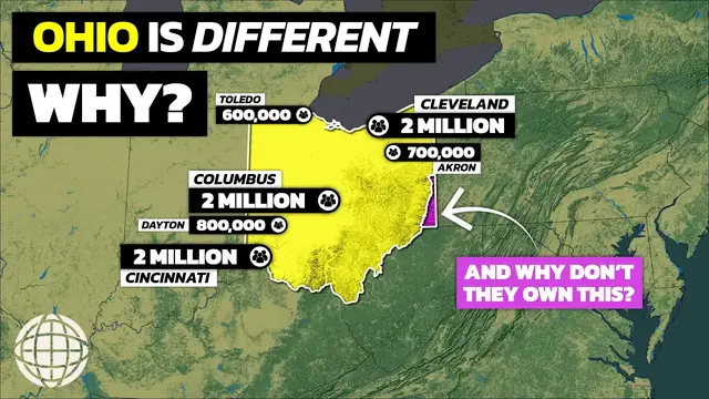
If you didn't notice throughout this section on geography, in nearly every region of the state, there's a pretty prominent population center
7:25
and this is unlike almost every other state in the country. Ohio's population distribution is uniquely balanced, with multiple metropolitan areas
7:37
each hosting significant populations rather than being concentrated in a single dominant city
7:42
This distinctive pattern is evident in the state's three largest metropolitan areas
7:46
Cleveland, Columbus, and Cincinnati, each with about 2.2 million people. Additionally, metropolitan areas such as Toledo, Akron, Dayton, Canton, and Youngstown also serve as substantial population centers
7:59
This even distribution is the result of historic, economic, and geographic factors that have shaped Ohio's development over time
8:07
Historically, Ohio's strategic location has played a crucial role in its population spread
8:12
Situated between the East Coast and the Midwest, Ohio became a critical hub for transportation and commerce in the 1800s
8:19
The construction of the Erie C in the 1820s connected the Great Lakes to the Atlantic Ocean via the Hudson River
8:25
facilitating the movement of goods and people. This led to the growth of Cleveland as a major port city
8:31
Similarly, the Ohio and Erie C linked Lake Erie with the Ohio River
8:35
enhancing the economic prospects of cities like Akron and Cleveland. The state's extensive rail network, developed in the mid-1800s, further encouraged urban growth
8:44
Railroads connected various parts of Ohio to the rest of the country, promoting industrial development in multiple cities
8:50
Cincinnati, located on the Ohio River, became a key river port and manufacturing center
8:55
attracting a diverse workforce and fostering economic prosperity. Columbus, centrally located, emerged as a transportation and logistics hub
9:04
eventually becoming the state's capital and a focal point for political and administrative activities
9:09
Ohio's industrial heritage also contributed to the even distribution of its population
9:14
During the late 1800s and early 1900s, the state became a powerhouse of manufacturing and industry. The state's availability of natural
9:21
resources such as coal and iron ore, combined with an extensive transportation network
9:26
supported the growth of factories and mills across the state. This industrial boom led to
9:30
the rise of cities like Dayton, known for its innovations in aviation and automotive industries
9:35
and Toledo, a key player in glass manufacturing. Geographically, Ohio's diverse landscapes have
9:40
supported various economic activities, contributing to the balanced population distribution, The fertile Lake Plains in the north support agriculture, while the Appalachian region in the southeast provides resources for mining and forestry
9:52
The central and southwestern parts of the state benefit from rich soils and favorable conditions for farming and livestock
9:58
This geographic diversity has enabled different regions to develop their own economic specializations, reducing the reliance on a single metropolitan area
10:07
Moreover, Ohio's commitment to infrastructural development has ensured connectivity and accessibility throughout the state
10:13
The well-maintained network of highways and interstates facilitates movement between cities and regions, promoting economic interdependence and regional development
10:20
This connectivity has allowed smaller metropolitan areas like Canton and Youngstown to thrive alongside larger cities In contrast to states with a single dominant metropolitan area Ohio multiple urban centers each contribute to the state economic and
10:33
cultural vitality. This balanced population distribution has created a diverse and resilient
10:38
economy, with various regions able to weather economic shifts and transitions. This doesn't
10:43
mean Ohio has been immune to economic downturns, but it does mean that when one city, such as
10:48
Cleveland, loses population and business, the state isn't entirely dependent on it, such as Oregon is
10:53
with Portland, where Minnesota is with Minneapolis. Today, Ohio would be led in population by the
10:58
Columbus and Cleveland metropolitan areas with about 2.2 million people apiece. This is followed
11:03
by Cincinnati, which technically has more people, though only 1.7 million actually live in Ohio
11:08
But again, Ohio's population is remarkably well distributed. Dayton is home to another 810,000
11:14
people, followed by Akron with 700,000. Toledo, Youngstown, and Canton would have a further
11:20
600,000, 425,000, and 400,000 people respectively. And there are many more cities across Ohio with at least 100,000 people
11:29
It really is quite remarkable when compared to states like Colorado, where over half of the state's population is located in the Denver metropolitan region
11:37
But in all of this discussion of history, geography, and population, you might have noticed one weird little area that feels like it should belong to Ohio
11:44
but is actually owned by West Virginia. The curious geography of West Virginia's northern panhandle, wedged between Ohio and Pennsylvania
11:55
often raises questions about why it isn't part of Ohio. And as usual, the reasons for this are rooted in colonial charters, territorial disputes, and historic agreements
12:04
The origin of the panhandle's borders date back to colonial times when the British crown granted charters to different colonies
12:11
In 1609, the Virginia Company received a charter for a vast territory that extended westward to the Pacific Ocean
12:17
including what is now West Virginia. This expansive claim was based on a principle known as Sea-to-Sea Grants
12:22
which allowed colonies to extend westward from their coastal boundaries. The Northern Panhandle began forming in 1779
12:28
when Pennsylvania and Virginia agreed to extend the Mason-Dixon line westward and then north to the Ohio River
12:34
In 1784, Virginia ceded its territory north and west of the Ohio River to the United States
12:41
retaining control of the 585 square miles between Pennsylvania's borders and the river
12:46
This narrow strip, extending 64 miles to Chester, became the northernmost part of West Virginia in 1863 when it split from Virginia
12:54
Near New Cumberland and Follensby, the Panhandle narrows to just 4 miles wide
12:58
Thus, the peculiar shape of West Virginia's northern panhandle is a result of historic colonial charters, early boundary settlements and negotiations, and the geographic significance of the Ohio River
13:09
These factors combined to create a unique territorial arrangement that persists to this day
13:15
Ohio is not often considered to be one of the most interesting states geographically
13:19
but its population distribution definitely makes a strong case. Over the coming decades, it'll be interesting to see if one city really starts to break away from the others
13:29
but that's not likely to happen for the foreseeable future. And today, Ohio is definitely not empty
13:35
Hey, do you love Ohio? Then be sure to check out some of these amazing Ohio maps over on my map store
13:41
Each would make a truly amazing gift for your favorite Buckeye. I hope you enjoyed learning all about
13:47
Ohio's unique population distribution. If you did, please subscribe to my channel
13:51
If you wanna watch more videos, click here. If you wanna listen to the podcast, click here
13:55
Thanks for watching. See you next time
#education