Up next in 10


Become a member on Patreon & get exclusive info! https://www.patreon.com/funwithflags
Join the Discord Server: https://discordapp.com/invite/uRTAdY9
Follow me on Twitter: https://twitter.com/GKonYoutube
Business Contact: [email protected]
Thanks for watching, remember to subscribe to catch future videos!
Special mention to my patrons: Richard, Vlad, Danny, Wilhelm, Taulant, Javier, Ryan, Pete, Cesar & Hendrick!
Show More Show Less View Video Transcript
0:00
We all know about countries borders, the imaginary lines which divide each nation's land on a world
0:08
map. But what we often forget, at least I do, is that there are also other boundaries, usually not
0:16
depicted on the maps we look at. Our planet's surface is only 29% land, the other 71% is water
0:24
and that territory must also be organized and divided according to area, zone and sovereignty
0:30
The first division we should talk about, and that I think pretty much everybody knows about
0:35
are oceans. We call them oceans because of the ancient Greeks, who in their classical mythology
0:41
had the story of a titan, the personification of the oceans called Oceanus. There are five oceans
0:47
in the world, the Pacific, the largest of all, which separates Asia and Australasia from the
0:53
Americas, the Atlantic, which separates Europe and Africa from the Americas, the Indian Ocean
0:59
bordering South Asia and separating Africa and Australia, the Southern or Antarctic Ocean
1:05
which encircles Antarctica itself, and the Arctic Ocean. On the other pole, up north
1:10
which borders North America and Eurasia, covering up much of the Arctic region
1:15
The oceans of the world are so large that when it comes to the seafloor, the bottom of the oceans
1:20
it's estimated that only about 5% of its territory has been mapped out due to how deep it is. That's
1:27
why sometimes we see those pictures of some weird looking fish that looks like a cow with a lamp on
1:33
its head. However, the surface of the water has, as far as I know, been entirely mapped out. And
1:39
other than the oceans, we have other ways that the waters are divided. There are subdivisions like
1:44
North and South Atlantic, South Pacific, etc. But those aren't important for this video. What I want
1:50
to talk about here are maritime boundaries. Each country, as long as it has a coastline
1:55
is entitled to a portion of the ocean, an extension of territory that goes beyond its
2:00
land into the water. In the case of islands, it is a radius around their territory. Inside
2:05
this portion of the ocean, the country has ownership and jurisdiction. However, the reach
2:10
of the country's control over the ocean is limited and doesn't go on forever. And so
2:14
the vast majority of the ocean belongs to no one and is known as international waters
2:20
therefore having no jurisdiction. Before we take a look at each country's sea zones and how these
2:25
sea borders exist, let's quickly mention these international waters, also known as the high seas
2:31
These are areas that exist under the mare liberum concept, sea zones where all countries have the
2:36
right to move through, fish, navigate, fly over, lay cables and pipelines, as well as conduct
2:43
scientific research, but none of them have the right to control it. In this map, we can get a
2:48
notion of how absolutely gigantic it is. In the light blue, we have the country's exclusive zones
2:55
which are then divided and organized amongst them as we see in a second And in the dark blue the vast majority of the oceans are the high seas international waters that belong to all countries and none at the same time However
3:08
this doesn't mean that you can do anything you want when you're in these waters. In order to be
3:13
there, unless you swam out, in which case congrats because you're an amazing athlete, you have to be
3:17
on a ship. And a ship must usually sail under the flag of a country. So while in international waters
3:24
the jurisdiction of said country applies to that ship. And if there are, for instance
3:29
pirating or criminal incidents, any country can enact the law and persecute those criminals
3:34
in international waters, according to the rules of universal jurisdiction. There are some curious cases of isolated international waters surrounded by country
3:43
zones, like these two small ones off the coast of Texas, these in the Arctic Ocean
3:48
one off the coast of Madagascar for some reason, and a bunch of them between the islands of the
3:53
Oceania area as well as the Pacific. So, to the point of the video. Those light blue areas in the
3:59
map. These are the waters that are under the jurisdiction of specific countries. Each country
4:04
has their own area, with the exception of landlocked states. Within a country's water
4:08
the territory is divided into mainly two areas. The territorial water, which is immediately adjacent
4:15
to the land, and the exclusive economic zone. The territorial sea is, as defined by the 1982
4:21
United Nations Convention on the Law of the Sea, a belt of coastal waters extending at most 12
4:27
nautical miles, which equal 22.2 kilometers. This area belongs entirely to that country and
4:34
would function if desired as a hard border, where external ships and airplanes are forbidden to
4:39
pass through without permission of the owner country. Then after that, countries can claim
4:43
their economic exclusive zone, which extends from the coast into a maximum of 200 nautical miles
4:49
which is around 370 kilometers. This means that the coastal nation has control of all economic
4:56
resources in that area, like fishing, mining, oil exploration, etc. However, they can't prohibit
5:03
other countries from passing through it, something that they can do in the territorial waters
5:07
Since the exclusive economic zone is bigger and thus necessarily contains the territorial waters
5:13
let's take a look at those because they are what in fact define countries' borders at sea
5:18
It's important to say that almost all countries claim a larger exclusive economic zone than they
5:24
currently have because probably they are aware that most of the ocean is unclaimed and assuring
5:29
their control over those portions means that they are likely to find more resources that might be
5:35
present in those areas. A good example of this is Portugal who because of the Azores and Madeira
5:40
archipelagos already has a significantly large economic zone but wants to expand it even more
5:46
In dark blue, we can see the additional area that they have laid claim to
5:50
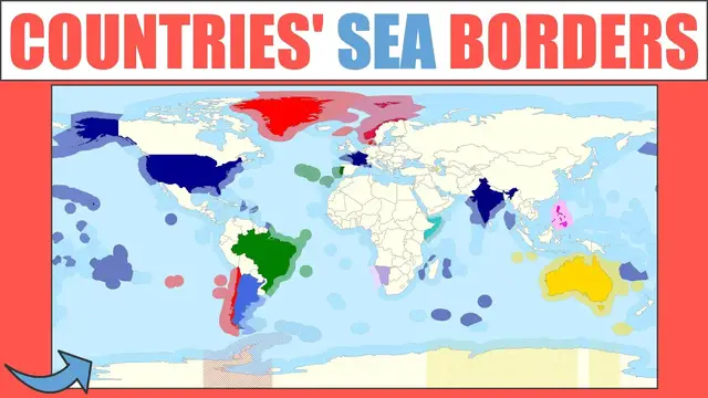
Now, I can't go one by one because we'd spend hours in this video, so what I'm gonna do is
5:54
show you a generalized map that merges countries' landmass with their sea area
5:59
to demonstrate how significant the increase in territory is for some of them Some countries jump aside straight away Portugal like I said Spain as well Norway Iceland Although keep in mind this is a map projection and country sizes near the poles are distorted and too big
6:14
Canada has a big territory in between all their northern islands. Caribbean nations instantly gain territory and Bermuda as well
6:22
Over in the east, Indonesia is huge, just like the Federated States of Micronesia
6:27
which in reality are just tiny, tiny islands. We can take a more detailed look in this map
6:34
which shows us exactly what is land and what is sea. Although sadly, I can only find a map like
6:39
this for Oceania and the Pacific. Micronesia is a great example. They are the 176th country
6:46
in terms of landmass. But when it comes to sea area, they are the 14th largest. Same with Kiribati
6:54
ranking 171, but 12th in EEZ size. Australia and New Zealand also have significant gains
7:01
and French Polynesia too. In fact, I feel like islands are the biggest beneficiaries of this
7:06
because they have a free radius around them to claim territorial and economic zone waters
7:12
not being limited and land blocked by other countries, as is the case with most of African
7:17
nations that have no coast, or even by some coastal countries in Europe, like Germany
7:22
who has a very small economic zone as it is immediately blocked by neighboring states
7:27
And before we take a look at specific countries' areas, a final mention here
7:31
This area in white and red stripes is also important because it's an example of a disputed area
7:37
There are a few sea zones across the world whose control is disputed between two or more countries
7:43
The South China Sea is, unfortunately, a good example of this. A place with so many tiny islands, some natural and some artificial
7:51
and with great strategic importance both economically and military-wise. This area is
7:56
claimed by six countries, China, Malaysia, Vietnam, Brunei, the Philippines, and Taiwan
8:02
with some overlapping areas. The tension that has arised from these disputes, I think
8:07
shows us how important and significant these sea areas are and why we should pay more attention
8:13
to sea borders across the world. So, now that we have a general notion and picture of how these
8:19
border's look across the world, let's take a quick look at some specific and interesting countries
8:25
Australia is an interesting case. They have the whole surrounding area of their continental land
8:30
mass, plus other smaller ones in their dependencies and islands around, as well as their claim on
8:35
Antarctica, which would grant them an increased coastline. I really need to make a whole video
8:40
about Antarctica and who owns it, all the issues around it. Canada is interesting simply due to two
8:45
facts. They have so many small islands in the north, and the economic zone, or territorial waters
8:51
unite them all under their sovereignty. And also, they break the US's continuous line across the
8:57
west coast of North America, separating their mainland from Alaska. Chile has a big area
9:02
what looks like about three times its land size also stretching into some islands and their South Pole claim Denmark a small country has a big area because of the Faroe Islands and Greenland
9:13
Although again, remember, this is a distorted map, projection, and Greenland and consequently
9:19
the sea area around it aren't as big as they seem here. Two of the most interesting examples
9:24
are France and the UK. France is the country with the biggest exclusive zone in the world
9:29
But they don't even have a large portion of the ocean near to their mainland
9:33
They have one of the largest economic zones because of the remnants of their colonial empire
9:39
The many islands that the French Republic still controls today across the world
9:44
in the Caribbean, Indian Ocean, and the Pacific, make it so that they are effectively the kings of the ocean
9:50
The country in the world that controls the biggest portion of the sea
9:54
The UK also has a pretty high reach and for the same reasons
9:58
Their colonial empire may be over, but they retain control over many small islands across
10:04
the oceans. Norway has a big area, the only case of a country having rulership overseas in both
10:10
of Earth's poles. The north through their mainland and offshore islands, and in the south through their island
10:16
domain and the Antarctic claim. Russia is big because, well, Russia is big
10:20
Their gigantic north and east coastline allowed them to stretch out into the ocean a lot
10:25
Plus, they're also able to claim a little bit of the Baltic, the Black Sea, and the Caspian Sea
10:31
And finally, the US, who has a significant size due to Alaska, its large mainland coasts
10:37
and their island possessions in the Pacific, as well as Puerto Rico. The top 10 countries in terms of EEZ size are France, the US, Australia, Russia, the UK, Indonesia, Canada, Japan, New Zealand, and Brazil
10:50
Countries with large coastlines are necessarily in a better position, as are the islands
10:55
Kiribati, Micronesia and the Marshall Islands all occupy slots in the top 20 despite being
11:01
incredibly small. Other honorable and surprisingly big size mentions within the top 30 are Portugal
11:08
the Solomon Islands, Seychelles, Mauritius and Fiji. Only 151 countries slash dependencies
11:14
have these areas while landlocked countries obviously do not. Within the ones that do have
11:20
it, the smallest belong to Bosnia, Jordan, Slovenia, Monaco, and Singapore. So that is essentially how
11:27
sea borders work, how they exist, how they are defined, and how the countries of the world
11:32
control them according to their location, coastal line, and island possessions, allowing us to
11:37
understand how the majority of the ocean and the surface of our planet belongs to no one and
11:42
everyone at the same time, and how the parts that do belong to countries are organized and divided
11:48
amongst them. Thanks so much for watching this video. If you notice any mistakes or have any
11:53
additional information, leave a comment below and subscribe if you want to catch future videos
11:57
I will see you next time for more general knowledge
#Freight Transport
#Hobbies & Leisure
#Water Activities
#Boating
#Surf & Swim
#education
#Military
#Diving & Underwater Activities
#Navy